
You are currently browsing the category archive for the ‘Ancient monuments’ category.
By Myghal Map Serpren
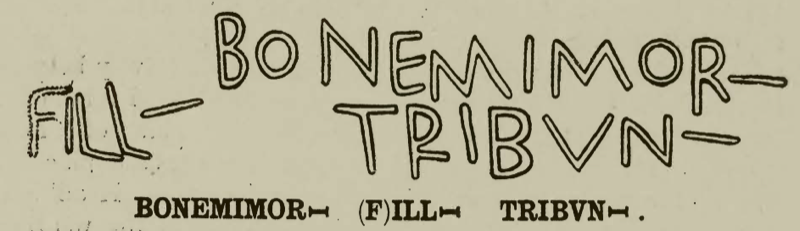
Now on display in the Royal Cornwall Museum, Truro in Cornwall, what has become known as the Rialton Stone is an inscribed close-grained granite Christian memorial stone dating from the Early Mediaeval period (410 – 1065), probably the early 6th century.
The stone was first written of in 1814 by the antiquarians Samuel Lysons FSA FRS (b.1763 d.1819) and his brother Daniel Lysons (b.1762 d.1814) who recorded that it “supports a shed in a back court at Rialton House”.

Rialton is situated just East of Saint Columb Minor in Cornwall and an Early Mediaeval ecclesiastical settlement there was incorporated into a later manor and farm.
Rialton was recorded as ‘Ryalton’ in 1283, this being a combination of two words, the Cornish ‘ryal’ meaning ‘royal’ or ‘regal’ and the Old English ‘tun’ meaning ‘farm’ or ‘settlement’.
By August 1867, the inscribed stone had been built into the wall of a stable building at Rialton joining a number of other fragmentary inscribed stones incorporated into the farm buildings.
During 1991, the stone was carefully removed from the wall and sent to the Royal Cornwall Museum for safekeeping following consent obtained from Charles, Duke of Cornwall (now King Charles III, b. 1948).
The Rialton Stone measures five feet seven inches in height and one foot eight inches across and is inscribed in two lines of Roman capitals: ‘BONEMIMORI ILLI TRIBVNI’.

The Latin firmly places the stone’s origins as being 6th century and thus reads:
‘BONEMIMORI (missing name) (F)ILLI TRIBUNI’ translating into English as ‘In loving memory of (name), a son of Tribunus’.
Examining the stone in 1994, the late Professor Charles Thomas CBE DL FBA FSA FSA Scot (b.1928 d. 2016) noted that the top part of the stone is missing and that it would have been inscribed with the name of the son who initially laid buried beneath it.
Writing in 1945, the renowned archaeologist Professor R.A.S. Macalister RIA RSA Ire (b.1870 d.1950) of University College, Dublin offered an alternative explanation of the inscription and suggested that the first word should be divided in two so reading ‘BONE MOMORI’ and translating as ‘the memorial of Bona’.
Tribunus or Triphun was the later 5th-century Irish-descended King of Demetia, the Celtic Kingdom of the Demetae which occupied what is now Pembrokeshire and Carmarthenshire in Wales.
Stones such as the Rialton Stone commemorated noteworthy people during the Early Christian period. They have been discovered elsewhere in lanns (Early Christian enclosures) as well as on boundaries, trackways and fords. They are often inscribed with Irish, British and Latin names and occasionally Ogham, the early Mediaeval Irish alphabet.
Only one face of the Rialton Stone is inscribed.
This fascinating memorial is accessible to the public being an exhibit in the Royal Cornwall Museum, River Street, Truro, Cornwall where an admission fee is charged. A link to the museum’s internet website is here: https://www.royalcornwallmuseum.org.uk
References
- Placenames in Cornwall and Scilly – Craig Weatherhill, Wessex Books in association with Westcountry Books, Launceston, Cornwall 2005
- Victoria History of the County of Cornwall, Volume 1 – Edited by William Page FSA, Archibald Constable and Co. Ltd., London, 1906 https://archive.org/details/victoriahistoryo00pageuoft/mode/2up?q=Rialton
- Corpus Inscriptionum Insularum Celticarum, Volume 1 (Duchy of Cornwall) – Professor R.A.S. Macalister, University College, Dublin, Stationery Office, Dublin, 1945Corpus Inscriptionum Insularum Celticarum, Volume 1 (Duchy of Cornwall) – Professor R.A.S. Macalister, University College, Dublin, Stationery Office, Dublin, 1945 https://www.irishmanuscripts.ie/digital/CorpusInscriptionInsularumCelticarumVolI/Corpus%20Inscription%20Insularum%20Celticarum%20Vol%20I.pdf
All images author’s own, except where stated.
See similar articles by Myghal Map Serpren
This week, courtesy of regular contributor Myghal Map Serpren, we have taken an in-depth look at the church at Breage, near Helston. See Part 1 and Part 2. We conclude with a look at a Roman stone and some crosses.
Saint Breaca Church’s Heritage Area
Saint Breaca’s Church is also a repository for many items of historic interest which are displayed in a ‘heritage’ area as well as elsewhere about the building.
The Roman Marker Stone
An item of great interest in this display is a marker stone from the Roman period 258 to 268.

Constructed from granite and measuring approximately five feet seven inches in height by one foot three inches in width, the pillar was rediscovered in 1920 when it was being used as a gatepost at cottages near the church. To allow for this, a hole had been drilled on the right side.
Demolition of the cottages occurred during 1922 and in 1923 and the pillar was recognised for what it really was and recovered to the safety of the church by the then Vicar of Saint Breaca.
A cut inscription in Latin on the stone reads:
“IMP C /DONO/MARC/CASSI/ANIO IMP(ERATORIO) C(AESARI) DO(MINO) NO(ST) (RO)MARC(O) CASSIANIO LATINO POSTUMO PIO FEL(ICI) AUG(USTO)”
This translates as “’to the Emperor Caesar our Lord Marcus Cassianus latinus postumus, pious, fortunate, august”
Marcus Cassianius Latinius Postumus, whose origins lay with the Germanic Batavi tribe, was a Roman Commander and general in command of the Lower Rhine army who declared himself Emperor of the Gallic Empire which broke away from the Roman Empire in the period 260 to 274. Comprising the territories of Britannia, Germania, Gaul, Raetia and for a period, Hispania, Postumus’ rule continued until 269 when he was assassinated by his own soldiers.
The engraved stone dedicated to him may well relate to his visit to Cornwall made during the Winter of 260 to 261 when it is believed he inspected Cornwall’s age-old tin and copper industry and trade.
This is the only surviving stone in Britain bearing a dedication to Postumus and it likely served as a route marker.
The ‘Spernon’ or ‘Sparnon’ Latin Cross
The heritage area also contains a granite Latin cross which dates from the Mediaeval period (1066 to 1539).
Now rather damaged, the upper limb of the cross is missing although a figure of Jesus Christ wearing a loin cloth and with outstretched arms is just visible.

The origins of the cross are unknown.
It was first properly recorded during 1887 when it was said to have been at Spernon (otherwise known as Sparnon) Cross where it was part of a hedge, from whence it was taken to the relative safety of Godolphin churchyard.
Sadly, Godolphin Church was closed in 1998 and so the cross was taken to Saint Breaca’s Church where it remains.
Measuring one foot nine inches in height and with the cross piece being one foot six inches across, there is every reason to believe that the cross was a gable cross rather than a wayside or freestanding structure.
The Saint Breaca Sculpture
Amongst much else, the heritage area also contains a modern sculpture dedicated to Saint Breaca. Sculpted in clay and cast in resin, surrounded by a halo of oak and mounted on a plinth of Canadian Douglas fir, the work by sculptor Bob Dawson and churchwarden Trefor Bowen is an impressive interpretation of the Saint herself, whose life is still commemorated over 1,500 years after she arrived on these shores.

Saint Breaca’s Churchyard Cross
Standing in the churchyard close to the South porch of Saint Breaca’s Church, a four-holed churchyard cross has drawn much attention over the years.

Believed to date from around 1200 by Professor Charles Thomas CBE DL FBA FSA FSA Scot (b.1928 d.2016), the round-headed monument had lain buried in the churchyard until its rediscovery during the 19th century.
However, writing in the volume on Cornwall of his Architectural Guides and published variously between 1951 and 1974, Professor Sir Nikolaus Bernhard Leon Pevsner CBE FBA (b.1902 d.1983), the distinguished art and architectural historian places the cross to an earlier 9th century period and describes it as being “a four holed wheel cross with Hiberno-Saxon decoration”.
Unusually for Cornwall, the cross is carved from red sandrock which is not found in the area and it is mounted on an octagonal base stone possibly from some later period.
Standing at a height of one foot three inches and measuring some one foot ten inches in diameter, the head has four holes with a short length of shaft remaining.
A central boss is just visible but due to extreme deterioration, the once elaborate decoration has all but disappeared.
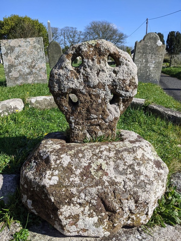
Just what the decoration was intended to represent has been subject of much debate.
An early suggestion made by John Thomas Blight FSA (b.1835 d.1911) writing of the cross in his 1865 edition of ‘The Churches of West Cornwall’, informs that there were once five bosses, one in the centre and one at each of the four limbs. This appears to have been superseded by the observation of a knot design on the limbs rather than bosses together with incised edge moulding.
In his ‘Old Cornish Crosses’ published in 1896, the antiquarian and author Arthur G. Langdon records the existence of an engraving resembling a dragon’s head on the cross but nothing of the bosses other than the central one.
Meanwhile, writing in ‘Cornish Crosses, Christian and Pagan’ by T.F.G. Dexter BA BSc PhD Royal Institution of Cornwall (b.1860 d.1933) and Henry Dexter and published post mortem in 1938, it was recorded that only one central boss was visible. T.F.G. Dexter regarded the cross as being of the ‘Maltese variety’ and noted the existence of the dragon’s head and suggested this represents the serpent, a Pagan symbol.
There are some fascinating myths relating to the cross.
Arthur G. Langdon records that he was informed that a great battle took place at the base of the nearby Godolphin Hill and that the cross was constructed of sand soaked with the blood of those who were killed.
A more likely and scientific explanation advanced by Ann Preston-Jones, Elisabeth Okasha and others in their ‘Early Cornish Sculpture’ published in 2013 and again in ‘Ancient and High Crosses of Cornwall’ by Ann Preston-Jones, Andrew Langdon and Elisabeth Okasha published in 2021, is that the monument was stained red by iron oxide whilst it lay for lengthy periods in stagnant water.
Summary
With Saint Breaca’s Church in Breage being a listed building, together with most of the monuments and memorials and many of the tombstones contained in the churchyard, a visit to the church is highly recommended.
Set in a conservation area as it is, this indeed represents a fascinating glimpse into the many periods of history and events dating from the 5th century to modern times.
The church remains a place of Christian worship and access is available most days.
A link to the relevant part of the West Kerrier benefice’s website can be found here, and the Friends of Saint Breaca Church maintain an excellent and very informative website.
Grateful thanks are extended to the churchwarden of Saint Breaca’s, Mr Trefor Bowen and to Mr Ian Gowing for arranging the visit and being such welcoming hosts. It was heartening to witness many visitors attending the church and learning something of the place and its people.
References
- Placenames in Cornwall and Scilly – Craig Weatherhill, Wessex Books in association with Westcountry Books, Launceston, Cornwall 2005
- The Cornish Church Guide and Parochial History of Cornwall – Charles Henderson, D.Bradford Barton 1964
- Curiosities of Cornwall – Margaret Caine and Alan Gorton, S.B. Publications, 2001
- An Imperial Possession – Professor David Mattingly FBA, Allen Lane, 2006
- Stone Crosses in West Cornwall – Andrew Langdon, Federation of Old Cornwall Societies, Cornwall 1999
- Ancient and High Crosses of Cornwall – Ann Preston-Jones. Andrew Langdon and Elisabeth Okasha, University of Exeter Press, 2021
- Early Cornish Sculpture – Ann Preston-Jones, Elisabeth Okasha and Others, British Academy, 2013
- Cornish Crosses, Christian and Pagan – T.F.G. Dexter BA BSc PhD, Henry Dexter, Longmans Green and Co., 1938
- Old Cornish Crosses – Arthur G. Langdon, John Romilly Allen, Joseph Pollard Pub. of Truro, Cornwall 1896 (available on the Internet Archive: https://archive.org/details/oldcornishcrosse00lang/mode/2up)
All images author’s own, except where stated.
See similar articles by Myghal Map Serpren
This week, courtesy of regular contributor Myghal Map Serpren, we are taking an in-depth look at the church at Breage, near Helston. See Part 1.
The Mediaeval Wall Paintings
Renovations to the church made during 1891 and later during 1955 revealed nine truly magnificent 15th-century wall paintings which were previously covered beneath whitewash following the Reformation of 1549 which resulted not only in huge loss of life but also considerable destruction to churches and other buildings as Roman Catholicism was swept aside following the creation and imposition of the Church of England.

Painted over, these images were hidden from view for well over 300 years.
To preserve them, a glazing process was carried out in 1935 and many now visit the church to view these remarkable paintings.
These comprise a nine-foot-high image of Saint Christopher carrying the Christ Child and wading across a river and an image of the Sabbath Christ which were painted on either side of the North door.

The depiction of Christ is surrounded by images of various tools and implements and it has been said that this represents Jesus blessing the various trades of the agricultural community. Perhaps more ominously, the image has also been interpreted as a warning to those who may feel tempted to work on the Sabbath Day upon whom eternal damnation would surely be visited for failure to observe the seventh day.

These are followed by other images painted on the North wall comprising Saint Hilary, the Breton Saint Corentin, an Archbishop possibly Saint Ambrose, Saint Michael the Archangel trampling on a dragon and finally 16th-century Gothic text which recorded verses 10 and 14 from Chapter Four of the Book of Proverbs.

Across the North Aisle, Nave and South Aisle and adjacent to the South door, paintings on the South wall depict King Henry VI, uncovered during 1955, although there is some suggestion that it depicts Saint Germoe, thence Saint Thomas a Becket, Saint Giles and finally an ornamental design. It is thought that this latter painting may have formed a background to a figure standing on a destroyed stone image bracket.

The Godolphin Chapel
At the Eastern end of the South Aisle, a chapel has been dedicated to the Godolphin family and commemorates Margaret Godolphin nee Blagge (b.1652 d.1678), who lies buried there. She was the wife of Sidney Godolphin, 1st Earl of Godolphin (b.1645 d.1712) who served as Lord Treasurer and First Minister on three occasions between 1684 and 1701 as well as being MP for Helston between 1665 and 1685.
The surname ‘Godolphin’ had been Anglicized from ‘Godolghan’.
Their family seat was at nearby Godolphin House of which parts date from 1475, and from the 12th century, their descendants grew in power, influence and wealth, boosted considerably during the boom years of Cornish mining. The manor and extensive grounds are now in the possession of the National Trust and form part of the UNESCO World Heritage estate.
The Godolphins chose Saint Breaca as their parish church and their family vault is situated in the chapel bearing their name with their tombs and memorials set about the church.
Suspended high above the chapel are three ceremonial funerary helmets and the wall is partly decorated with beautifully painted tiles which have been subject to restoration.

The Trewavas Reliquary
Standing above the altar table in the chapel, a large carved stone with a pointed head probably dating from the 14th century, depicts the Crucifixion with Jesus Christ on the cross and figures of Saint John and the Virgin Mary set to each side.

The letters ‘B’ and ‘I’ are carved on the edges of the point perhaps being personal initials or even ‘B’ for Breage.
The rear of the stone has been hollowed suggesting that it was originally a reliquary and it has had something of a chequered history and perhaps a miracle that it still exists.
Discovered at Tremearne Farm, a mile distant from Breage, it may well have been part of a Mediaeval chapel but of this structure, there is now no trace.
It was later removed to Trewavas where it was used as a trough for pigs.
An article which was published in ‘The Cornishman’ newspaper in 1881 recorded it as being mounted on a garden wall of the Count House at Trewavas Mine.
During the early 20th century, the stone was again moved to Kerthen in Saint Erth from where it was rescued in 1956 by the Reverend Canon Hugh Robert Coulthard MA, then Vicar of Breage, and safely placed in Saint Breaca’s Church.
Fragments of original stained glass
The window on the South side of the Godolphin Chapel is of interest in that it contains two fragments of early stained glass which depict the heads of angels and which before the restoration of 1891 were hidden in a walled-up staircase which leads to the rood loft – the gallery above the magnificent rood screen. A further fragment of the same Mediaeval period which depicts the head of Saint Veronica was placed in the window in the South Transept. The original stained glass windows were smashed during the upheavals of 1549.
Also displayed on a wall adjacent to the Godolphin Chapel is a board displaying the letter of thanks sent by King Charles I to the people of Cornwall for their loyalty during the Civil War of the 1640s.
References
- Placenames in Cornwall and Scilly – Craig Weatherhill, Wessex Books in association with Westcountry Books, Launceston, Cornwall 2005
- The Cornish Church Guide and Parochial History of Cornwall – Charles Henderson, D.Bradford Barton 1964
- Curiosities of Cornwall – Margaret Caine and Alan Gorton, S.B. Publications, 2001
- An Imperial Possession – Professor David Mattingly FBA, Allen Lane, 2006
- Stone Crosses in West Cornwall – Andrew Langdon, Federation of Old Cornwall Societies, Cornwall 1999
- Ancient and High Crosses of Cornwall – Ann Preston-Jones. Andrew Langdon and Elisabeth Okasha, University of Exeter Press, 2021
- Early Cornish Sculpture – Ann Preston-Jones, Elisabeth Okasha and Others, British Academy, 2013
- Cornish Crosses, Christian and Pagan – T.F.G. Dexter BA BSc PhD, Henry Dexter, Longmans Green and Co., 1938
- Old Cornish Crosses – Arthur G. Langdon, John Romilly Allen, Joseph Pollard Pub. of Truro, Cornwall 1896 (available on the Internet Archive: https://archive.org/details/oldcornishcrosse00lang/mode/2up)
All images author’s own, except where stated.
See similar articles by Myghal Map Serpren
Next: A Roman stone and the church crosses.
This week, courtesy of regular contributor Myghal Map Serpren, we shall be taking an in-depth look at the church at Breage, near Helston.
Breage and Saint Breaca
The village and parish of Breage is located some three miles West of Helston in Cornwall.
Recorded as ‘Egglosbrec’ in 1140, this Cornish name is derived from ‘eglos’, the Cornish for ‘church’ combined with the Saint’s name. This became ‘Eglosbrek’ by 1181 and during 1207, ‘Eglospenbro’. ‘Penbro’ is Cornish meaning ‘end of a region’.
Now known as Breage, properly pronounced ‘braig’, the church or ‘Ecclesia de Egglosbrec’ as it was recorded in 1150, now exists as a 15th-century building with many unique historical features and artefacts.
Dedicated to Saint Breaca, it is said that she was one of a large number of Christian missionaries who arrived on the coast of Cornwall during the 5th century bringing with them the message of Jesus Christ. Originating from Ireland and Wales, these holy women and men evaded capture and established religious settlements across Cornwall.

Breaca chose the hillside at what was to become Breage as her settlement leaving her brother Germoe choosing a nearby valley and spring for his.
It is therefore entirely possible that the site was established as a lan during the early Mediaeval period (410 to 1065) and this appears to be reflected in the circular enclosure about the church which exists to this day. There is also a possibility that an Iron Age (c.750BCE to 43CE) mound existed on the site, which may have been chosen as a suitable spot for a lan.
Saint Breaca’s Church
The church at Breage today dates from the 15th century and has been described as one of Cornwall’s finest examples of such.

Dedicated in 1456, it replaced an earlier 13th-century structure of which nothing now remains apart from two small stone fragments.
This fine granite building consists of a chancel, nave, north and south aisles, north and south transepts, a west tower and south porch with the chancel and altar in the centre, with the Godolphin Chapel on the South side and a three-stage, buttressed tower on the North West end.

Externally, the tower, transepts and South porch are all battlemented with carved granite heads and gargoyles set about the cornice of the tower.
Standing at a height of 67 feet with an internal arch leading into the nave, earlier is a chime of eight bells cast locally from an earlier single bell said to have weighed 26 hundredweight, itself cast from three Mediaeval bells.

The tower clock was a gift made in 1910 by a Cornelia Carter then of Philadelphia, USA in memory of her late husband, William Thornton Carter, a Breage man who, along with many others, had departed Cornwall to seek their fortunes overseas.
References
- Placenames in Cornwall and Scilly – Craig Weatherhill, Wessex Books in association with Westcountry Books, Launceston, Cornwall 2005
- The Cornish Church Guide and Parochial History of Cornwall – Charles Henderson, D.Bradford Barton 1964
- Curiosities of Cornwall – Margaret Caine and Alan Gorton, S.B. Publications, 2001
- An Imperial Possession – Professor David Mattingly FBA, Allen Lane, 2006
- Stone Crosses in West Cornwall – Andrew Langdon, Federation of Old Cornwall Societies, Cornwall 1999
- Ancient and High Crosses of Cornwall – Ann Preston-Jones. Andrew Langdon and Elisabeth Okasha, University of Exeter Press, 2021
- Early Cornish Sculpture – Ann Preston-Jones, Elisabeth Okasha and Others, British Academy, 2013
- Cornish Crosses, Christian and Pagan – T.F.G. Dexter BA BSc PhD, Henry Dexter, Longmans Green and Co., 1938
- Old Cornish Crosses – Arthur G. Langdon, John Romilly Allen, Joseph Pollard Pub. of Truro, Cornwall 1896 (available on the Internet Archive: https://archive.org/details/oldcornishcrosse00lang/mode/2up)
All images author’s own, except where stated.
See similar articles by Myghal Map Serpren
Next: some of the internal features of the church, including some spectacular medieval wall paintings.
By Myghal Map Serpren
To say that the cross standing at the West front of Truro Cathedral in Cornwall’s only city has been damaged and battered during its time would be something of an understatement.
Now standing at ten feet in height, this reconstructed granite wheel-headed cross, thought to date from the 12th century CE, was struck by a manoeuvring motor vehicle during February 2019 and broken into four parts.

The monument is held in such fondness that it was fully restored and returned to High Cross by December that same year.
This part of Truro known as ‘High Cross’ was recorded as such in a document dating from 1290CE which refers to a stone cross in the now city as “crucem lapideam burgi de Truru.”
There is reasonable doubt though that this refers to the cross we see today.
The current cross was actually found in 1958 during excavations by road workers digging a trench at the junctions of Victoria Place and River Street with St Nicholas Street in Truro.

Its discovery came to the attention of Mr. Henry Leslie Douch, then curator of the Royal Institution of Cornwall, who arranged for it to be placed outside the Royal Cornwall Museum in River Street, Truro.
It comprises a typical granite wheel-head cross with splayed arms and a central boss in relief with longstanding damage to one side of the head and in its original form measuring some three feet 11 inches in height.
During 1959 it was re-sited and placed on a granite base in a flower border at High Cross.
The cross was again moved in 1981 during cobbling of the area and languished outside a store premises where it could not be fully appreciated.
The cross’s plight came to the attention of then Councillor and later Mayor of Truro, John Christie, a gentleman who did so much for the city and its cathedral (known to this writer).
Councillor Christie set about raising the funds to allow for the cross to be properly mounted and having been successful in this respect, the cross was taken to Hantergantick granite quarry near Saint Breward near Bodmin.
There, an extremely skilled stonemason cut a new shaft and the original cross was attached to it, increasing the monument from its original three feet 11 inches to ten feet.
The cross was re-erected at High Cross, Truro in March 1988.
Later, at the end of his term of office as Mayor of Truro in May 1992, Councillor Christie oversaw the re-dedication of the cross by the then Dean of Truro, the Very Reverend David Shearlock.
The recognised expert on Cornish crosses, Andrew Langdon, has noted that in his opinion, the original ‘High Cross’ at Truro was more likely to have been a Gothic monument and that this current and rather well-travelled cross now standing proudly in front of the cathedral is more likely a typical wayside cross.
Whatever, it is an impressive monument carefully restored following the collision damage of 2019, which now appears to be secure for the future.
References
- Stone Crosses in West Cornwall – Andrew Langdon, Federation of Old Cornwall Societies, Cornwall 1999
- Ancient and High Crosses of Cornwall – Ann Preston-Jones. Andrew Langdon and Elisabeth Okasha, University of Exeter Press, 2021
All images author’s own, except where stated.
See similar articles by Myghal Map Serpren
By Myghal Map Serpren
This granite Latin style wayside cross was found by a local Redruth builder, Mr. N. Thomas in 1939, built into the stable wall of the former Rose Cottage public house in Chapel Street, Redruth.
It is thought to date from the earlier part of the Mediaeval (1066CE to 1539CE) period and to have been connected with the now-lost Saint Rumon’s Chapel which was situated in Chapel Street beneath the now ruined Gem Cinema and Druid’s Hall which currently serves as a public garden space and occasional outdoor performance area.

Saint Rumon’s Chapel was licensed during 1400CE and possibly served as a sanctuary for pilgrims travelling to visit Saint Michael’s Mount further West.
By 1745CE, the chapel is described as being in a ruinous state and architectural fragments of it are found contained in the adjacent Murdoch House, once the home of William Murdoch (b.1754CE d.1838CE) the 18th century steam and gas engineer and inventor, as well as in the now community space.
Following its rediscovery in 1939, records show that by 1943, the cross was propped up against a hedge to the rear of the Rose Cottage.
Fortunately, the Redruth Old Cornwall Society took possession of it in 1993 when it was placed in secure storage.
In May, 2000, Saint Rumon’s Cross was mounted on a new base adjacent to Murdoch House and on the site of the vanished Saint Rumon’s Chapel.
Virtually round in section, the cross measures four feet two inches high, with the head being just under one foot two inches across and the shaft measuring between six and seven inches in width and is now a Grade II Listed Building.
References
- Stone Crosses in West Cornwall – Andrew Langdon, Federation of Old Cornwall Societies, Cornwall 1999
All images author’s own, except where stated.
See similar articles by Myghal Map Serpren
By Myghal Map Serpren
Found in the forecourt of the Wesleyan Chapel in Chapel Street, Camborne in Cornwall, this wheel-headed cross has had several names and now appears secure following something of a journey around the parish.
Dating from the Mediaeval period (1066CE – 1539CE), this granite cross is now sadly broken off beneath its neck, measures around two feet two inches in height, with the head being some one foot five inches in diameter, what remains of the upper part of the shaft measuring around one foot three inches across and just under ten inches in thickness.

One face of the head displays an incised image of Jesus Christ with outstretched arms and legs cut off at knee level. The reverse has a Greek cross in relief enclosed within a bead.

The cross is known variously as the ‘Kitty’s Lane Cross’, the ‘Killivose Cross’ and perhaps less imaginatively as ‘Trevu Number Two Cross’.
Historical accounts have it that a Mr. W. Roberts, a gardener at Trevu recovered the cross during 1883CE where he found it in a hedge alongside the road running East from Barripper to Ramsgate, Little Pendarves, Killivose and up the hill to Beacon, near Camborne, described by some in those times as ‘the old Roman road from Penzance to London.’
It is thought that the original site for the cross was at the T-junction where Kitty’s Lane, now Killivose Road joins the above road.

A field near this junction, then part of John Eva’s farm at Killivose, was recorded as being named ‘Growsey’ on the tithe map, a Cornish language name derived from ‘an grows’ – ‘the cross’ – with the Cornish for cross, ‘crows’ mutating to ‘grows’.
A Mr. Smith retained the cross in his house grounds at Trevu until it was later moved again to the home of a relative of his, Mr. W.D. Tyack.
Arthur Langdon writing in 1896CE, recorded the monument as standing in Mr. Tyack’s garden at 4, Beacon Terrace, Camborne.
It remained at this address until 1970CE when Mr. Tyack’s widow presented the cross to the Wesley Chapel where it was mounted and remains to this day.
It is now a listed structure and hopefully safe following its rather uncertain past.
References
- Old Cornish Crosses – Arthur G. Langdon, John Romilly Allen, Joseph Pollard Pub. of Truro, Cornwall, 1896 (available on the Internet Archive: https://archive.org/details/oldcornishcrosse00lang/mode/2up)
- Stone Crosses in West Cornwall – Andrew Langdon, Federation of Old Cornwall Societies, Cornwall 1999
- Christian Antiquities of Camborne – Professor Charles Thomas, H.E. Warne Ltd., 1967
All images author’s own, except where stated.
See similar articles by Myghal Map Serpren
By Myghal Map Serpren
The Parish of Gunwalloe situated on the Lizard Peninsula in Cornwall was recorded as ‘Wynwala’ in 1499 and named after Saint Winwalo or Winwaloe.
Winwaloe (b. c.460 d. 532) was a Breton Saint and the son of a Prince of Dumnonia, Fracan, and his wife, Gwen Teirbron and he is patron of several churches in Cornwall including that at Gunwalloe as well as one in Devon and two in Wales.
It is thought that the site occupied by the current church which dates from the Mediaeval (1066 to 1539) period may have previously been a ‘lann’ and by the 5th century, a church had been established there of which nothing now remains.

cc-by-sa/2.0 – © habiloid – geograph.org.uk/p/6182433
Referred to during 1433 as the chapel of “St Wynwola iuxta Carmynow”, the earliest part of the present Church of Saint Winwaloe is the detached two-storey bell tower embedded in the side of the cliff which dates from the 13th century. The main church building dates from the 15th century although may contain fragments from an earlier structure and was extensively restored from 1869 following storm damage with the architect overseeing this work being Edmund Sedding (b. 1836 d.1868) whose practice was based in Penzance and who restored or almost entirely rebuilt many church buildings throughout Cornwall and further afield.

Inside the church, which comprises a chancel, nave, north and south aisles, the oldest item is the badly damaged Norman font constructed of Pentewan stone, the sole object from that time with a later font there dating from the 15th century.
Known as ‘The Church of Storms’ due to its position next to the sea and also owing to many graves in the churchyard where sailors have been interred who lost their lives off the coast, some of the woodwork in the church is reputed to be from shipwrecked vessels.

Just a few feet to the East of the church building and contained in the churchyard stands a wheel-headed former wayside cross which is thought to date from the early Mediaeval period.

This granite cross is believed to have once acted as a wayside marker on a pathway used by pilgrims which crossed a nearby stream and it has been said that it lay on the stream bed for many years.
It was subsequently recovered and taken to the nearby Penrose Estate before being placed in the churchyard mounted on its granite base during 1875.
Here it remains and stands at a height of just over one foot on its base.
One face of the head displays an equal limbed cross in relief and although many authors have written that such a cross appears on the reverse side, there appears no trace of this as the photograph below shows and the Cornwall and Isles of Scilly Historic Environment Record further informs that this side of the cross head is indeed plain.

There are records of a nearby Holy Well dedicated to Saint Winifred but of this, there are no visible remains.
Both Saint Winwaloe Church and the wayside cross are Listed Buildings and are fully accessible to the public.
References
- Placenames in Cornwall and Scilly – Craig Weatherhill, Wessex Books in association with Westcountry Books, Launceston, Cornwall 2005
- Old Cornish Crosses – Arthur G. Langdon, John Romilly Allen, Joseph Pollard Pub. of Truro, Cornwall, 1896 (available on the Internet Archive: https://archive.org/details/oldcornishcrosse00lang/mode/2up)
- Stone Crosses in West Cornwall – Andrew Langdon, Federation of Old Cornwall Societies, Cornwall 1999
- The Cornish Church Guide and Parochial History of Cornwall – Charles Henderson, D.Bradford Barton 1964
All images author’s own, except where stated.
See similar articles by Myghal Map Serpren
By Myghal Map Serpren
Found languishing in the churchyard alongside the porch of the redundant Church of Saint John the Baptist at Godolphin Cross, a Mediaeval (1066CE – 1539CE) Latin cross stands as a memorial to the Christian beliefs of another time.

The church fell redundant in 2005 and left Godolphin Cross, a village four or five miles northwest of Helston in Cornwall, sadly deprived of the use of a fine Gothic place of worship dating from the mid-1800’s.
The church is now in private ownership and with a churchyard increasingly clogged with natural growth, it is hoped that the granite cross will survive.

This is not the first uncertainty faced by the memorial for it served as a gatepost on the nearby former Chytodden Estate until March, 1886CE, when due to the efforts of the Reverend S. Rundle, vicar of Godolphin, it was moved to the church and preserved there in the churchyard.
Writing of it in 1896CE, Arthur Langdon described it as being six feet six inches in height but it is assumed that the cross shaft is buried deep as it does not stand to that height now with the Ordnance Survey recording it as being five feet three inches high.

Measuring around two feet in width, the weathered cross head bears an incised cross on one face only with the reverse left plain and it appears that the base of the shaft was originally squared to allow for mounting on a plinth.

The Chytodden Cross has been recorded as a Grade II Listed Building as is the church and so we trust that despite the current abandoned state of the building and churchyard, its future remains secure.
References
- Old Cornish Crosses – Arthur G. Langdon, John Romilly Allen, Joseph Pollard Pub. of Truro, Cornwall, 1896 (available on the Internet Archive: https://archive.org/details/oldcornishcrosse00lang/mode/2up)
- Stone Crosses in West Cornwall – Andrew Langdon, Federation of Old Cornwall Societies, Cornwall 1999
See similar articles by Myghal Map Serpren
By Myghal Map Serpren
This little granite wheel-headed wayside cross stands in a hedge recess alongside the A394 road at Trevena (correctly pronounced Trevenna and oft spelt that way) Cross in the parish of Saint Breage (Breaca) in West Cornwall.
Dating from the Mediaeval (1066CE to 1539CE) period, the cross is sadly very worn and mutilated with a section from the top missing.

Writing in 1888CE to local historian and schoolmaster Mr. S.J. Wills (b.unknown d.unknown), the Reverend Edward Morris Pridmore MA (b.unknown d. unknown), then Vicar of St. Breaca, recorded that the cross previously stood in a hedge and was later moved and erected on a plinth stone on a triangular area of grass at the centre of the road junction at Trevena Cross.

Research carried out by local historian and writer Michael Tangye revealed that when the cross stood in this road junction, it was used by local children as a wicket during games of cricket played when the roads were considerably safer and less used.
Trevena Cross was relocated to its current site in 1924CE when another vicar, the Reverend Canon Hugh Robert Coulthard MA (b.1860CE d.1939CE) funded its removal to a far more secure stone-lined recess in the hedge.
Here it remains, a memorial from an earlier time now witness to the massive increase in speeding traffic and the flow of visitors along the A road and to the Trevena Cross Nursery and Garden Centre which lies just across the other side of the road.
Standing at approximately one foot nine inches, the remaining cross head measures one foot two inches across and bears a Latin Cross on each face with the upper section lost.
The substantial plinth indicates that the cross was once much larger if indeed it be the original mounting.
Trevena Cross is a Grade II Listed Building and a Scheduled Monument.
References
- Old Cornish Crosses – Arthur G. Langdon, John Romilly Allen, Joseph Pollard Pub. of Truro, Cornwall, 1896 (available on the Internet Archive: https://archive.org/details/oldcornishcrosse00lang/mode/2up)
- Stone Crosses in West Cornwall – Andrew Langdon, Federation of Old Cornwall Societies, Cornwall 1999
All images author’s own, except where stated.
See similar articles by Myghal Map Serpren


You must be logged in to post a comment.