The Journal has been maintained since March 2005 to promote awareness and the conservation of the incomparable but often-threatened heritage sites of Britain, Ireland and beyond.
It is with intense sadness, and a deep sense of loss that we have to report that Nigel Swift, Chairman of Heritage Action (HA) for 20 years, passed away on Monday evening. He had been living with prostate cancer for over 20 years, but had discovered during a recent stay in hospital that the cancer had spread. Despite this, his final weeks were full of laughter, surrounded by his family, and his final days at a wonderful hospice passed in tranquility and painlessness.
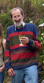
Nigel Swift
Nigel Swift graduated in Economics and Politics (University of London) and was a Fellow of the Royal Institution of Chartered Surveyors. He has published articles and lectured at various universities on surveying-related topics. Following his early retirement in 2001, he expanded a keen interest in archaeological conservation issues. He was a co-founder and Chairman of UK and Ireland group Heritage Action which is dedicated to voicing the concerns of many ordinary members of the lay public on various matters relating to heritage conservation.
Nigel was a keen participant on the Head Heritage forums, and was known for his strong views against metal detectorists. Indeed, over the years he made few friends in that area and endured many extreme reactions to his views, including threats of violence, but as he once said – ‘What are they going to do to me? There is nothing they can do to me.’
Knowing that the end was near, Nigel requested that we post the following poem on his behalf:
Relative Ron
This is the story of Relative Ron, Admittedly dead, but not really gone. He explained what he meant as he breathed out his last (He didn’t have long so he talked very fast):
“They say that the universe is without limit, So clearly I’ll always be someplace within it. And although it might seem that my time has now passed, This can hardly be true in arrangements so vast: For boffins contend that space-time is bent And reverses on reaching an horizon-event. So don’t look so gloomy, for clearly it’s plain Right now in the future we’ll all meet again.”
Below are some of the early reactions to the news of Nigel’s passing, showing how well respected and loved he was among the amateur antiquarian community.
I’m so, so sorry to hear this! Absolutely gutted. I really loved that bloke. I’ll miss the daft old sod.
We ADORED Nigel. His refusenik righteousness, his fire, his intelligence, his curiosity, kindness and humanity. If you knew him you were lucky. And weren’t we so lucky?
The quintessential troublemaker, you’ll be missed Nigel. The twenty-plus years of your life hammering against heritage theft, unfettered metal detecting, vandals etc etc are testament to your spirit. The humour and passion you did it with came for free. My favourite memory is telling me to be calm when approaching people climbing stones at Avebury in one minute then angrily yelling “oi, you can’t climb that” two minutes later. Never shy in coming forward. Rock on mate.
He once told me he was working as a chartered accountant somewhere, and when he was taken ill and got a “six-months-to-live” diagnosis – his firm told him he need not come in and they’d give him full pay until he died… in the end, and this was some years later, they (as he put it) sued him for not dying [I am sure the legal term is probably different].
Devastated. Even though we knew it was coming. I shall miss his phone calls, his quips, his laugh. I am not even sure of his age but first met him in person in 2000. We met in a pub on Salisbury Plain and conceived what eventually became Heritage Action, albeit I then refused to join. Nigel then came up with the meeting which took place at the ‘orse (the Uffington White Horse, which led to the formation of HA ).
There is so much more that could be said. Fare well on the other side Nigel. The world is a worse place without you…
Today Save Stonehenge World Heritage Site (SSWHS) learnt that its judicial review of the Government’s decision to approve a highly damaging, £2.5bn road scheme through Stonehenge World Heritage Site, for a second time, had been unsuccessful. Mr Justice Holgate in handing down his judgement today dismissed the application. SSWHS have said that they intend to appeal the decision.
The judgement comes after a 3 day hearing in the High Court in December. UNESCO, five planning inspectors and over 236,000 people were all opposed to National Highways’ highly damaging plans. Save Stonehenge WHS’s legal action had been the only thing stopping the giant earthmovers from entering this 5,000-year-old landscape.
John Adams, chair of the Stonehenge Alliance and one of the 3 directors of SSWHS, said:
“In the face of Government indifference to the harm this road will cause the World Heritage Site, we had no choice but to bring this legal action. While this judgement is a huge blow and exposes the site to National Highway’s state sponsored vandalism, we will continue the fight. In the dying days of this Conservative Government, which has inflicted so much damage on the country, we cannot let it destroy our heritage as well.”
Tom Holland, historian and president of the Stonehenge Alliance, said:
“This is a devastating loss, not just for everyone who has campaigned against the Government’s pig-headed plans for the Stonehenge landscape, but for Britain, for the world, and for subsequent generations.”
SSWHS successfully raised over £80,000 to bring this action. SSWHS will now have to raise a further £15,000 in order to apply for permission to appeal at the Court of Appeal. If a hearing is granted, a further £40,000 could be required.
The CrowdJustice page has a new interim target of £100,000. This is to raise the additional funds needed to make an application for permission to appeal (at the Court of Appeal). If a hearing is granted, the CrowdJustice target is likely to need to rise to around £140,000.
Nance Farm is found in Illogan near Redruth in Cornwall. The valley which the farmland overlooks is wooded, and at its base, the B3300 road leading from Redruth enters the seaside village of Portreath with its former industrial port and harbour.
Nance derives from the Cornish word ‘nans’ meaning ‘valley’ and the word is in use in many other placenames throughout Cornwall as well as being a family name.
Situated on a high spur of land at the farm and overlooking the valley below as well as the valley which joins it from Illogan, an earthen round stands guard and is thought to date from the Iron Age period, 800BCE to 42CE.
As is common across Cornwall, most fields are named, and during the 18th and 19th centuries the one in which the round stands was called ‘Goon an geare’ which translates from Cornish as ‘downland of the fort’. This later became ‘Gullen Gear’, thence ‘Golden Gear’.
Nance round or hill fort comprises an oval part bivallate structure with the greater diameter being around 380 feet and the lesser 341 feet.
The surrounding ramparts are between around six feet and six feet seven inches in height and the ditches, of which there originally appear to have been two, currently measure around two feet four inches in depth. The double ditch remains on the southwest side of the round.
Rampart and ditch Nance Round (Cornwall Council)
The entire round occupies an area of around two acres.
An additional rectangular enclosure appears to have existed as an appendage on the southeast side of the round, a fairly rare feature.
The ’round’ is complete except where a section of the outer bank and ditch on the North to North East side has been removed.
No obvious entrance to the round has ever been identified.
Nance and Nancecuke Rounds as drawn by Charles Henderson 1916
Prehistoric (500,000BCE to 42CE) flint scrapers have been found on site.
A matter of a few feet to the West of the enclosure there are traces of an oval ring ditch earthwork measuring some 78 feet 9 inches by 59 feet. Nothing is visible at ground level but this has featured on aerial photographs.
Current analysis informs that it was probably a Bronze Age (2500BCE to 801 BCE) round barrow which has been ploughed down over the years.
Nance round has been used as part of the ceremonies observed by Gorsedh Kernow and indeed, the late Craig Weatherhill (b.1951 d.2020), noted Cornish historian, archaeologist, toponymist and author was Barded there in 1981 for his services to Cornwall.
There have been suggestions from many sources that Nance round and hillfort served as a trading post. This is entirely possible bearing in mind its close proximity to the cove below and the sea is known to have washed further inland into the valley than it presently does.
A local tale informs that the earthwork is of Roman origin and was the site of a great battle in the distant past. However, it predates the arrival of any Roman influence although a battle may have occurred there as others are recorded along the local stretch of coast and adjacent moorlands.
The round is situated on farmland and access is best requested from the landowner.
Nancekuke
Of interest is the fact that immediately across the deep valley below Nance which now carries vehicular traffic from further inland along the B3300 to Portreath, a sister earthwork is recorded at Nancekuke.
Image from Google Earth showing the round at Nance and the Nancekuke airfield across the valley
Nancekuke which was recorded in 1170 as ‘Nanscoig’ is a Cornish placename deriving from ‘nans cog’ meaning ’empty valley’.
This earthwork was also a round dating from a similar period to the one at Nance and was written of by renowned antiquarian and historian Charles Henderson (b.1900 d.1933) who at a very young age visited the site during 1916 noting:
“On the other side of the valley (from Nance) is the hamlet of Great Nance-kuke, and between it and the cliffs, a distance of about a half mile, are the scanty remains of a small earthwork. It stands in a field and has been greatly ploughed down, though its outline can still be traced. The interior was raised artificially to make a level space and hence, though the enclosing rampart has been quite ploughed away, a terrace still marks its site. This terrace is still further emphasized by a shallow depression around it—all that is left of the encircling fosse. As will be seen on the plan, a hedge intersects the camp on the west side, and the shape is oval, 65 yards by 45 yards, not circular. At ‘A’ (referring to his sketch, see above) the terrace is quite 5 ft. in height.”
The Royal Air Force assumed control of the larger part of Nancekuke at the commencement of the Second World War and by 1941, the airfield constructed there became RAF Portreath, a Fighter Command station. The building of runways and other structures wiped away many ancient sites and although the site is no longer an active airfield, a chemical warfare establishment was on the former air station from the early 1950s through to the end of the 1970s and tons of toxic nerve agents produced and stockpiled there causing widespread environmental damage and death to employees. The area remains in use as an air defence radar station with upgrades being carried out as recently as 2020. Limited public access does occur for specific events.
Before the destruction inflicted to clear the area had occurred, field placenames which were recorded during the 18th century give a clear indication of the existence of a sister to the round and fort at Nance just opposite.
One such field had the name ‘Geer’ deriving from the Cornish ‘ker’ or ‘cayr’ meaning ‘fort’ and another ‘Todden Kere Common’ from the Cornish ‘todn ker’ translating as ‘grassland of, or by the fort’.
The site of the round at Nancekuke was visited by an Ordnance Survey fieldworker during 1970 and he recorded a slight oval feature measuring approximately 164 feet by 197 feet.
Nearby several implements dating from the Mesolithic (8000BCE to 4000BCE) and Neolithic (4000BCE to 2500BCE) periods were recovered during archaeological excavations carried out during 1940 by Charles Kenneth Croft Andrew (b.1899 d.1981). Amongst other artefacts, these items comprised arrowheads, scrapers, blades and borers and a cup marked stone.
A nearby barrow of which there are no remains probably due to wartime construction work, was also examined by Andrew resulting in him recording the presence of a grave pit, a fire site and a charcoal patch. Pottery thought to date from the Bronze Age (2500BCE to 800BCE) as well as a holed and a cupped stone were found together with the remains of an oak Cornish shovel at the base of a ditch surrounding the barrow site which measured some 56 feet in diameter.
References
Placenames in Cornwall and Scilly – Craig Weatherhill, Wessex Books in association with Westcountry Books, Launceston, Cornwall 2005
Cornovia – Ancient Sites of Cornwall and Scilly – Craig Weatherhill, Halsgrove, Somerset, 2009
Cornish Archaeology – Hendhyscans Kernow Number 10 – Journal of the Cornish Archaeological Society, 1971
We conclude Myghal Map Serpren’s look at Camborne Church by focussing on the Churchyard Crosses.
The Connor Downs Cross ‘MaenCadoar’
The Connor Downs Cross perhaps better known as ‘Maen Cador’ is found in the churchyard to the West of the tower.
Also known as ‘Meane Cadoarth’, ‘Meane Cadoacor’ and ‘Maen Cadoar’, with ‘Maen’ deriving from the Cornish ‘men’ meaning ‘stone’ and with the descriptor being a personal name, this long stone is believed to date from the Bronze Age (2500BC to 801BC) but was subject to extensive alterations to convert it into a Christian cross in the Early Mediaeval to Mediaeval period.
The Maen Cadoar Cross
It was initially situated on the boundary of the Gwithian and Gwinear Parishes at Connor Downs and recorded in the Gwinear parish records of 1613 as “Maen Cadoarth” and “the Battle Stone” and in 1651 as “the long stone called Meane Cadoarth”. By 1755 it was said to be laying at a roadside between Camborne and Redruth and by 1896 it had become a gate post. Finally, the landowner of the Rosewarne Estate, Mr. Van Grutten, allowed the stone to be moved to its current position in 1907.
Maen Cadoar, obverse view
Measuring six feet ten inches in height with the width of the head being approximately 11 inches, the width of the shaft at the top is eight and half inches which reduces to one foot ten inches, alteration to the head of the former menhir made during the Medieval period (1066 to 1539) resulted in a cross formed by four rounded triangular sinkings. The shaft of the stone is beaded and the decoration consists of a panel with lines of shallow holes.
Local tradition now recorded informs that each hole represents the life of a man killed at the great battle at Reskajeage Downs.
Nothing is currently known of this battle. Some have speculated that the Cadoc included in toponymical research of Reskajeage is in the Cornish Royal lineage of King Doniert and that the spur and battle were named for him. Cadoc, also known as Condor, Candorus and other names, was a legendary Cornish nobleman and 16th Century antiquarians recorded him as being Earl of Cornwall during the Norman conquest.
Reskajeage itself was recorded as Roscadaek in 1317, Reskaseak Downs in 1673, Riskejeake Downs in 1723 and finally Reskajeage Downs in 1888, the name translates from the Cornish ‘ros Cajek’ as ‘Cadoc’s hillspur’. The downs themselves are named after the settlement of Ruschedek recorded in 1235.
Perhaps one of the greatest mysteries of Maen Cadoar is the real possibility that it commemorated a great battle which occurred back in the mists of time.
The Crane, Fenton-Ia or Saint Ia’s Cross
A Mediaeval (1066 to 1539) wayside cross known variously as the Crane Cross, Fenton-Ia and Saint Ia’s Cross stands in the churchyard just over 30 feet southwest of the church building.
The Crane Cross
It was recorded as being in the grounds of the now vanished Saint Ia’s Chapel at Reens in the nearby Troon during 1750 by that great antiquarian, geologist and naturalist the Reverend William Borlase (b.1696 d.1772).
By 1896, it was recorded as being at Crane on the outskirts of Camborne where it was employed as a support for a well’s winding mechanism and five holes had been drilled into the cross shaft and remain to this day as evidence of its misuse.
It was subsequently recovered to Saint Martin and Saint Meriadoc’s Church where it remains.
Standing to a height of some six feet one inch with the head measuring around one foot six inches in diameter and nine inches in thickness, this granite cross is marked with an equal limbed cross with expanding limbs extending towards a beaded edge.
Crane Cross, obverse view.
The monument is quite worn but on one side of the cross shaft which now faces East there is decoration consisting of vertical lines and triangles which is barely visible.
It has been cemented onto a rectangular cross base, also of granite and a cement repair has been conducted near the base of the shaft.
With a slate plaque bearing the words “This ancient Cornish cross was found at Crane, Camborne”, this cross base is worthy of note in its own right.
An iron link remains on the base and the parish stocks were once attached to this.
Current thinking has it that the base was probably part of an original churchyard cross now known as the ‘Chancel Wall Cross’ which is mounted on the external East wall of the church building.
The ‘second’ Crane Cross
The so-called ‘Second Crane Cross’ has now been built into the church wall just inside the South door.
Having also been repurposed during a later period as part of the well workings at Crane as had occurred with the Crane or Saint Ia’s Cross, this small cross slab was discovered under the Saint Ia’s Cross during 1896 by Joseph Holman.
It is thought that this cross slab was carved to place on the wall of the now long lost chapel which stood at Crane and was never designed to be a freestanding wayside cross.
According to the local historian and author Thurstan Collins Peter (b.1854 d.1917) who saw the cross before it was mounted in its current position, the reverse face appeared unfinished possibly due to a flaw in the granite.
A broad limbed Latin cross is visible on its exposed side and the bottom of this ends with a square step.
Brought to the relative safety of the churchyard shortly after its discovery, it was subsequently taken into the church itself and later fixed to the wall inside the South door where it remains.
The Chancel Wall Cross
The final cross to be discussed is known as the ‘Chancel Wall Cross’ for it has been built into the exterior of the Eastern wall of the South Aisle of the church below the window.
This cross is of granite and in what has become known as the Greek style with limbs which expand toward the circumference of the head.
The chancel wall cross
Measuring one foot seven inches in height by one foot seven and half inches in width, a reference to it by the then Curate of the neighbouring All Saints Church at Tuckingmill and a keen antiquarian, the Reverend Arthur Adams, the cross was recut before being mounted which explains its excellent condition.
The Cornish archaeological artist John Thomas Blight FSA (b.1835 d.1911) made note of this cross during 1860 and sketched it.
By 1878, work on the South Aisle of Camborne Church was completed and the cross was built into the external wall where it remains to this day.
As previously noted, it is more than likely that the original base for this cross is now used in the Crane Cross.
Summary
As will be gathered, there is much of great historical interest at Saint Martin and Saint Meriadoc’s Church in Camborne, far more indeed than could ever be written in a precis such as this.
The building and many of the monuments about it are listed and scheduled but this church is primarily a place of worship and a community hall to the rear is used for many different events.
Of note is that part of the interior is undergoing renovation and the original stonework is being exposed which may contain yet more secrets. A brief examination revealed a stone with chevron markings during our visit.
The chevron stone, revealed during recent renovations.
In addition to Sunday services, the church is open to visitors on Tuesdays from 2pm to 4pm and Saturdays from 10am to 12 noon although it is strongly advised that before any visit is made, the necessary enquiries are carried out with the church.
Grateful thanks go to the Church Warden and lay preacher Mr David Fieldsend and to Mrs. Fieldsend for being such charming and accommodating hosts during the visit to this magnificent church.
References
Placenames in Cornwall and Scilly – Craig Weatherhill, Wessex Books in association with Westcountry Books, Launceston, Cornwall 2005
A Guide to Cornish Place-Names – R. Morton Nance, The Federation of Old Cornwall Societies, 1950
Cornish Church Guide And Parochial History Of Cornwall – Charles Henderson M.A., D. Bradford Barton Ltd., Truro, 1964
Stone Crosses in West Cornwall (including The Lizard) – Andrew Langdon, Federation of Old Cornwall Societies, 1999
Ancient and High Crosses of Cornwall – Ann Preston-Jones, Andrew Langdon, Elisabeth Okasha, University of Exeter Press, 2021
Early Cornish Sculpture – Ann Preston-Jones, Elisabeth Okasha and Others, British Academy, 2013
Cornish Crosses, Christian and Pagan – T.F.G. Dexter BA BSc PhD, Henry Dexter, Longmans Green and Co., 1938
We continue our visit to Camborne Church, with Myghal Map Serpren.
The ‘Leuiut Slab’
This remarkable inscribed altar stone slab which has become known as the ‘Leuiut Altar Slab’ is situated just forward of the screen on the South aisle of 1879 and into the Lady Chapel which was extensively renovated and restored in 1989.
Known as the ‘Pendarves Aisle’ after the influential and wealthy landowners of the period, the Pendarves family vault lays beneath the floor here.
Dated as being from the 10th century by the late Professor Antony Charles Thomas CBE DL FBA FSA FSA Scot (b.1928 d.2016), a local tradition has it that the slab originated from the now-lost chapel of Saint Ia near Troon, less than two miles distant. This has now been accepted as an accurate account of its origins.
The Leuiut Altar Slab
Constructed of red granite, the slab is inscribed with the words ‘’LEUIUT IUSIT HEC ALTARE PRO ANIMA SUA’ which translates as ‘Leuiut ordered this altar for the sake of his soul’.
Also found on the Leuiut Slab are five Consecration Crosses which are believed to have been engraved on it as part of a reconsecration which occurred during the later Norman times.
The Leuiut Slab lay in the churchyard for many years before being stored under the church’s Communion Table. It was placed in its current position as part of a First World War memorial scheme.
The slab is mounted on a slate pillar and is designed to closely resemble a similar altar in the village of Venasque in the Vaucluse department of Provence, France.
The Leuiut Altar has frequently been described as Saint Martin and Saint Meriadoc Church’s greatest single treasure.
The wooden cross placed on the slab was constructed of oak recovered from part of the 15th-century aisle roof above.
There is a macabre local tale regarding the Lady Chapel and the Pendarves Vault beneath it. This informs that The Honourable Sir William Pendarves (b.1689 d.1726) who was interred earlier had a coffin of copper constructed from the first of that metal brought up from his mine at the nearby South Roskear and was even known to drink punch from it at Pendarves House. During 1780, the vault and coffin were opened to inter the remains of another member of the family and those carrying out the work were confronted by the body of Sir William with hair and nails which had grown considerably.
The Mermaid and the Green Man
The Parish Church of Saint Senara in Zennor, Cornwall has been frequently visited and written of, owing to the legend of the ‘Mermaid of Zennor’ whose image is to be found on the 600-year-old ‘Mermaids Chair’. It is not generally realised that a mermaid exists in Saint Martin and Saint Meriadocs’s as well.
An examination of the Sanctuary at the head of the Chancel reveals walls panelled with former 15th-century bench ends which have a range of creatures carved on them including a mermaid.
The Camborne Mermaid
Other carvings include a Green Man, a pagan Celtic fertility symbol usually depicted with foliage growing from them or around them. These are found in a large number of churches and cathedrals but often need to be sought out.
The Camborne Green Man
The Sedilia, the bench designed for the priest, is similarly constructed of former bench ends dating from the 15th century.
The Oddfellows and other stained glass windows
Saint Martin and Saint Meriadoc’s has no less than 15 beautiful stained glass windows.
Five in the North Aisle commemorate individual families and date from the 1960s and depict ‘The Holy Family with the Arms of the Diocese of Truro and Saint Martin’, ‘The Marriage at Cana, Christ and the Children’, ‘The Triumphal Entry into Jerusalem’ and ‘Christ in Majesty’.
The East window of the Lady Chapel, continues the chapel’s close connection with the Pendarves family by having a magnificent collection of 29 heraldic shields which relate to the genealogy of the family. The window is dedicated to the memory of Edward William Wynne Pendarves (b.1775 d.1853) and dates from 1864.
The Pendarves Window
The East window of the outer South Aisle depicting ‘The Works of Mercy’ commemorates the Reverend Canon William Pester Chappel M.A. (also Chappell, Chapple etc) (b.Truro 1828 d.Camborne 1900) dates from 1898 and marked his 40th year as Rector of Camborne which commenced in 1858 and finally ended with his death.
Reverend Canon Chappel was indeed a popular clergyman for another stained glass window situated in the outer South Aisle depicting ‘Saint Peter, Saint Andrew and Saint James’ was dedicated to his memory during the year of his death, 1900.
The outer South Aisle also has stained glass windows depicting ‘The Last Supper and the Institution of Holy Communion’ dating from 1969 and in memory of members of the Gundry family, ‘The Washing of the Disciples’ Feet’ in memory of members of the Pellew family, ‘The Commissioning of the Apostles’ in memory of a further Rector of Camborne from 1934 to 1944, The Reverend Canon D.E. Morton and his wife and ‘The Parable of the Vine and Branches’ dating from 1961 in memory of members of the Odgers family. Many of these are longstanding local families with modern descendants.
The inner South Aisle has a window showing ‘Christ and the Impotent Man at the Pool of Bethesda’ dating from 1864 and in memory of Edward Lanyon.
The Belfry window shows ‘Saint Martin dividing his cloak with the beggar and Saint Martin’s Baptism’ and dates from 1862 having been funded by the younger men of the parish.
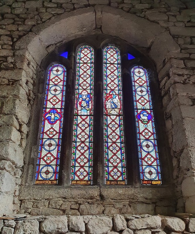
Of great personal interest is the West window in the North Aisle, ‘The Oddfellows’ Window’.
The Oddfellows Window on the North aisle
This was paid for by the Loyal Basset Lodge of the Oddfellows Friendly Society and consecrated by the Reverend Canon Chappel in 1863. It celebrates the marriage of the then Prince of Wales, Albert Edward, later King Edward VII (b.1841 d.1910), to Princess Alexandra of Denmark, later Queen Alexandra (b.1844 d.1925) which occurred on 10th March, 1863 at Saint George’s Chapel, Windsor Castle.
The Oddfellows Window on the North aisle
The four-light window was paid for by the Lodge bearing the family’s name at the then substantial cost of nine shillings and sixpence (47.5 decimal pence) per foot of glass, around £50 per foot in today’s prices.
Oddfellows window, detail
Bearing the dedication “Presented by the Odd Fellows of the Loyal Basset Lodge AD MDCCCLXIII” the first light depicts the Dove of the Holy Spirit, the second light the emblems and symbols of the Odd Fellows with the All Seeing Eye with the emblem of the Society beneath flanked by the maternal figure of Charity with children to the left and the female figure of Hope with her anchor to the right, the third light a widow and her children pursued by Want who approaches from over the late husband’s grave and the words “Widows’ & Orphans’ Fund over a figure representing succour and protection, with the fourth light depicting Agnus Dei, the Lamb of God, a symbol of Jesus Christ.
Oddfellows window, detail
These 15 windows are truly magnificent and worthy of close inspection.
Next time, we’ll look at the crosses in and around the churchyard.
References
Placenames in Cornwall and Scilly – Craig Weatherhill, Wessex Books in association with Westcountry Books, Launceston, Cornwall 2005
A Guide to Cornish Place-Names – R. Morton Nance, The Federation of Old Cornwall Societies, 1950
Cornish Church Guide And Parochial History Of Cornwall – Charles Henderson M.A., D. Bradford Barton Ltd., Truro, 1964
Camborne is situated in the former Hundred of Penwith in West Cornwall.
The Cornish language was the main tongue of the area until the early 18th century and so it follows that the name of the town is derived from the Cornish placename ‘Cambron’ which it was known as from c.1100 to c.1700. This translates from the Cornish ‘cam-bron’ into English as ‘crooked hill’.
Now very much a post-industrial settlement, it is perhaps difficult to believe that Camborne was once one of the most wealthy tin mining towns in the world, and home to the internationally recognised Camborne School of Mines and hard rock machinery production company, Holman Brothers.
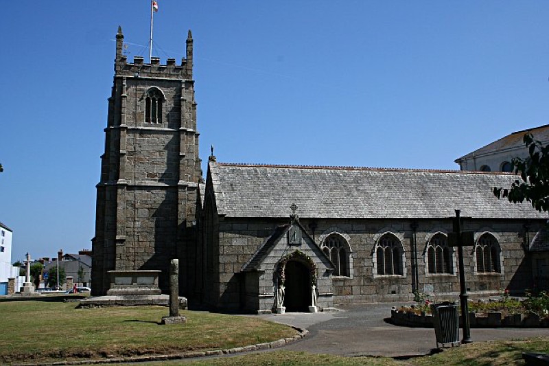
The Saint Martin and Saint Meriadoc’s Parish Church of Camborne
Camborne has a fine Parish Church dedicated to two Saints, the Celtic Saint Meriadoc (Meriasek in Cornish, Meriadocus in Latin) and St Martin. Thought to have lived around the 7th century and to have been Bishop of Vannes, Meriadoc is commemorated in Brittany, where both his bell and holy well are preserved and situated in Stival, a small village near Morbihan.
Camborne Parish Church by Tony Atkin via Creative Commons
An account of the life of Saint Meriadoc is contained in the Cornish language play ‘Beunans Meriasek’ (Cornish: ‘Life of Meriasek’) dating from 1504, which was rediscovered in Wales in 1869.
This tells of the Saint arriving in Camborne and founding a church beside the pre-existing chapel of Saint Mary.
During the 15th century, Saint Meriadoc’s patronage was shared with Saint Martin, Bishop of Tours in France (d. 397), a popular Mediaeval Saint.
During the Mediaeval era, both Meriadoc and Martin were recognised in Camborne, however, it was not until as relatively recently as 1958, following many years the Church became officially known as the ‘Church of Saint Martin and Saint Meriadoc’.
A Chapel of Saint Mary is recorded on the site in 1435 and 1445 and until 1671, two churches were contained within the surrounding walls, the parish church and a chapel and shrine dedicated to the Virgin Mother.
The Reformation saw the demise of the chapel and shrine which although renovated during the 1630’s, entered a period of terminal decline during the times of Oliver Cromwell (b.1599 d.1658) in the period 1653 to 1658. The building was then used as a source of stone to allow for the construction of a nearby poor house.
The structure of the current church dates mainly from the later 15th century although it does incorporate some fabric of earlier structures and has artefacts and monuments set in and about it from considerably earlier still. It has been suggested that the site was in use well before the Norman period. Sections of the wall enclosing the surrounding churchyard date from Mediaeval times.
Initial restoration of the church occurred during 1861 and 1862 followed by further considerable restoration and enlargement work during 1878 and 1879 under the supervision of the renowned church architect James Piers St Aubyn (b.1815 d.1895).
Church tower with Maen Cadoar
In addition to the existing 60-foot high, three-stage West tower which has eight bells, the nave and chancel and the North and South aisles, an addition to the South aisle was constructed together with a magnificent four-span roof.
Completion of this work allowed for an increase in the seated congregation from the earlier 488 to a remarkable 668 people.
There is much of interest both within and without the large church building, which we shall cover in Part 2 later this week.
References
Placenames in Cornwall and Scilly – Craig Weatherhill, Wessex Books in association with Westcountry Books, Launceston, Cornwall 2005
A Guide to Cornish Place-Names – R. Morton Nance, The Federation of Old Cornwall Societies, 1950
Cornish Church Guide And Parochial History Of Cornwall – Charles Henderson M.A., D. Bradford Barton Ltd., Truro, 1964
Originally Built To Defend Carrick Roads, It Later Surrendered Without A Shot Being Fired
By Myghal Map Serpren
Begun in 1540 and considered by many as one of the finest coastal fortifications constructed during the reign of King Henry VIII (b. 1491 d. 1547), Saint Mawes Castle in Cornwall was built along with Pendennis Castle, its sister across the water in Falmouth, to guard the strategically important Carrick Roads which make up the Falmouth Estuary, the world’s third largest natural harbour.
St Mawes Castle, with Carrick Roads beyond
Built during a time of international uncertainty, deteriorating relations between England, France and Spain were poor due to King Henry VIII’s divorce from his first wife, Catherine of Aragon (b. 1485 d. 1536) and the rift with the Catholic Church. State-sponsored piracy and privateering flourished and commonly occurred off the stretch of coast along Falmouth Bay. By 1538, with the alliance of France and Spain, invasion of England seemed likely and a large number of coastal fortifications came about.
In 1540, Lord Admiral Russell, the King’s Officer in the South West appointed a local man, Thomas Treffry (d. 1564) of Fowey to build Saint Mawes Castle and his work remains to this day.
St Mawes Castle
A three-year programme saw the construction of a large central tower with a small watch tower and three semi-circular bastions arranged in a cloverleaf design.
A gatehouse was built at the approach to the castle and a drawbridge and provision of musket loops. An artillery blockhouse was also constructed below the castle at the edge of the shoreline.
Saint Mawes Castle entrance from the South West
Designed to defend Carrick Roads, it was never intended that Saint Mawes Castle be in a position to resist any sustained assault from the landward side.
During March 1646, the Civil War was drawing to a close. Cornwall had held for the Royalist cause based on promises of increased autonomy but on the 15th March, 1646, Royalist forces surrendered at the nearby Tresillian Bridge just outside Truro. The victorious Parliamentary commander, Lord Fairfax, led his army to attack both Saint Mawes Castle and Pendennis Castle across the water in Falmouth.
With a small garrison at Saint Mawes, and being overlooked by the surrounding land, the castle under the command of a Lieutenant Bonython, surrendered without a shot being fired. Pendennis Castle though endured a three-month siege before finally surrendering with its garrison allowed to march out with full colours flying.
This was not the end of Saint Mawes’ military career however for it was later developed by the Victorians as a substantial coastal gun battery and was in use during both the First and Second World Wars with Falmouth being a major embarkation port for the D-Day operations.
By 1956, Saint Mawes’ time as an active military establishment had drawn to a close and it came into the possession of the State and remains one of the finest examples of King Henry VIII’s coastal artillery forts.
Fine views of Pendennis Castle, Carrick Roads and Falmouth and also of the fortified headland at Saint Anthony are to be had from its battlements.
View of Saint Anthony Head from Saint Mawes Castle
Now owned by the Duchy of Cornwall but managed by English Heritage, the castle is open to the public on payment of entrance fees and a small shop is to be found in the gatehouse.
Now on display in the Royal Cornwall Museum, Truro in Cornwall, what has become known as the Rialton Stone is an inscribed close-grained granite Christian memorial stone dating from the Early Mediaeval period (410 – 1065), probably the early 6th century.
The stone was first written of in 1814 by the antiquarians Samuel Lysons FSA FRS (b.1763 d.1819) and his brother Daniel Lysons (b.1762 d.1814) who recorded that it “supports a shed in a back court at Rialton House”.
The Rialton Stone
Rialton is situated just East of Saint Columb Minor in Cornwall and an Early Mediaeval ecclesiastical settlement there was incorporated into a later manor and farm.
Rialton was recorded as ‘Ryalton’ in 1283, this being a combination of two words, the Cornish ‘ryal’ meaning ‘royal’ or ‘regal’ and the Old English ‘tun’ meaning ‘farm’ or ‘settlement’.
By August 1867, the inscribed stone had been built into the wall of a stable building at Rialton joining a number of other fragmentary inscribed stones incorporated into the farm buildings.
During 1991, the stone was carefully removed from the wall and sent to the Royal Cornwall Museum for safekeeping following consent obtained from Charles, Duke of Cornwall (now King Charles III, b. 1948).
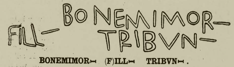
The Rialton Stone measures five feet seven inches in height and one foot eight inches across and is inscribed in two lines of Roman capitals: ‘BONEMIMORI ILLI TRIBVNI’.
The Rialton Stone as depicted in Victoria History County of Cornwall 1906
The Latin firmly places the stone’s origins as being 6th century and thus reads: ‘BONEMIMORI (missing name) (F)ILLI TRIBUNI’ translating into English as ‘In loving memory of (name), a son of Tribunus’.
Examining the stone in 1994, the late Professor Charles Thomas CBE DL FBA FSA FSA Scot (b.1928 d. 2016) noted that the top part of the stone is missing and that it would have been inscribed with the name of the son who initially laid buried beneath it.
Writing in 1945, the renowned archaeologist Professor R.A.S. Macalister RIA RSA Ire (b.1870 d.1950) of University College, Dublin offered an alternative explanation of the inscription and suggested that the first word should be divided in two so reading ‘BONE MOMORI’ and translating as ‘the memorial of Bona’.
The Rialton Stone engraving drawn by Professor R.A.S. Macalister 1945
Tribunus or Triphun was the later 5th-century Irish-descended King of Demetia, the Celtic Kingdom of the Demetae which occupied what is now Pembrokeshire and Carmarthenshire in Wales.
Stones such as the Rialton Stone commemorated noteworthy people during the Early Christian period. They have been discovered elsewhere in lanns (Early Christian enclosures) as well as on boundaries, trackways and fords. They are often inscribed with Irish, British and Latin names and occasionally Ogham, the early Mediaeval Irish alphabet.
Only one face of the Rialton Stone is inscribed.
This fascinating memorial is accessible to the public being an exhibit in the Royal Cornwall Museum, River Street, Truro, Cornwall where an admission fee is charged. A link to the museum’s internet website is here: https://www.royalcornwallmuseum.org.uk
References
Placenames in Cornwall and Scilly – Craig Weatherhill, Wessex Books in association with Westcountry Books, Launceston, Cornwall 2005
Whilst we await the result of the judge’s deliberations following the latest appeal against the tunnel on the A303 at Stonehenge, we can turn our attentions to what can be considered a yowling moggy by omission.
We should all be familiar with this delightful/horrendous (depending upon your viewpoint) image of the tunnel entrance as ‘planned’:
a pristine scene
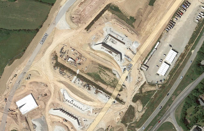
But that’s not half the story! Back in June last year, we provided a comparison with the A30 roadworks at Chiverton Cross in Cornwall, a project that is still ongoing with regular closures of the road and lengthy diversions.
some of the A30 ‘support infrastructure’
As if the potential temporary roadworks aren’t enough, a recent letter to the Salisbury Journal by a construction engineer, headed “fine detail missing from designs” points out some quite serious omissions in the Highways England image:
The tunnel will need electricity sub-stations, one at either end, water holding tanks for the fire suppression systems, holding tanks for the tunnel drainage water, an admin building for the tunnel staff and control room etc. It will also need an apron at either end for the breakdown recovery vehicles and emergency vehicles, and safe areas for evacuees in the event of a major incident. None of these structures/areas appear on the artist impression and they will be needed, some can perhaps be underground but not without significantly increasing the footprint of the site. All tunnels need smoke and extract fans and lighting so they are sources of pollution…
It will be interesting to see if/when an updated impression is released, showing the true picture. Unless of course, all of this infrastructure is to be omitted from the project – but that’s unthinkable, isn’t it??
This week, courtesy of regular contributor Myghal Map Serpren, we have taken an in-depth look at the church at Breage, near Helston. See Part 1 and Part 2. We conclude with a look at a Roman stone and some crosses.
Saint Breaca Church’s Heritage Area
Saint Breaca’s Church is also a repository for many items of historic interest which are displayed in a ‘heritage’ area as well as elsewhere about the building.
The Roman Marker Stone
An item of great interest in this display is a marker stone from the Roman period 258 to 268.
The Roman marker stone
Constructed from granite and measuring approximately five feet seven inches in height by one foot three inches in width, the pillar was rediscovered in 1920 when it was being used as a gatepost at cottages near the church. To allow for this, a hole had been drilled on the right side.
Demolition of the cottages occurred during 1922 and in 1923 and the pillar was recognised for what it really was and recovered to the safety of the church by the then Vicar of Saint Breaca.
A cut inscription in Latin on the stone reads:
“IMP C /DONO/MARC/CASSI/ANIO IMP(ERATORIO) C(AESARI) DO(MINO) NO(ST) (RO)MARC(O) CASSIANIO LATINO POSTUMO PIO FEL(ICI) AUG(USTO)”
This translates as “’to the Emperor Caesar our Lord Marcus Cassianus latinus postumus, pious, fortunate, august”
Marcus Cassianius Latinius Postumus, whose origins lay with the Germanic Batavi tribe, was a Roman Commander and general in command of the Lower Rhine army who declared himself Emperor of the Gallic Empire which broke away from the Roman Empire in the period 260 to 274. Comprising the territories of Britannia, Germania, Gaul, Raetia and for a period, Hispania, Postumus’ rule continued until 269 when he was assassinated by his own soldiers.
The engraved stone dedicated to him may well relate to his visit to Cornwall made during the Winter of 260 to 261 when it is believed he inspected Cornwall’s age-old tin and copper industry and trade.
This is the only surviving stone in Britain bearing a dedication to Postumus and it likely served as a route marker.
The ‘Spernon’ or ‘Sparnon’ Latin Cross
The heritage area also contains a granite Latin cross which dates from the Mediaeval period (1066 to 1539).
Now rather damaged, the upper limb of the cross is missing although a figure of Jesus Christ wearing a loin cloth and with outstretched arms is just visible.
The Spernon Cross
The origins of the cross are unknown.
It was first properly recorded during 1887 when it was said to have been at Spernon (otherwise known as Sparnon) Cross where it was part of a hedge, from whence it was taken to the relative safety of Godolphin churchyard.
Sadly, Godolphin Church was closed in 1998 and so the cross was taken to Saint Breaca’s Church where it remains.
Measuring one foot nine inches in height and with the cross piece being one foot six inches across, there is every reason to believe that the cross was a gable cross rather than a wayside or freestanding structure.
The Saint Breaca Sculpture
Amongst much else, the heritage area also contains a modern sculpture dedicated to Saint Breaca. Sculpted in clay and cast in resin, surrounded by a halo of oak and mounted on a plinth of Canadian Douglas fir, the work by sculptor Bob Dawson and churchwarden Trefor Bowen is an impressive interpretation of the Saint herself, whose life is still commemorated over 1,500 years after she arrived on these shores.
The St Breaca sculpture
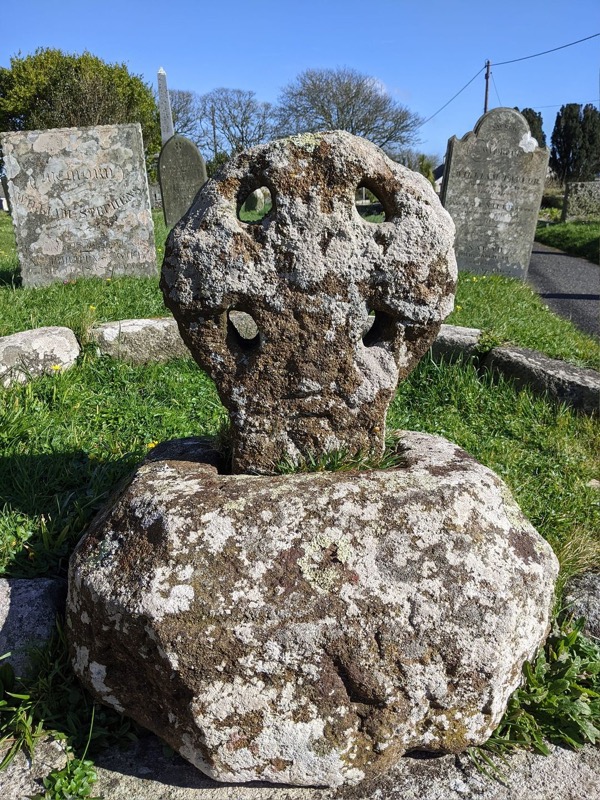
Saint Breaca’s Churchyard Cross
Standing in the churchyard close to the South porch of Saint Breaca’s Church, a four-holed churchyard cross has drawn much attention over the years.
The churchyard cross
Believed to date from around 1200 by Professor Charles Thomas CBE DL FBA FSA FSA Scot (b.1928 d.2016), the round-headed monument had lain buried in the churchyard until its rediscovery during the 19th century.
However, writing in the volume on Cornwall of his Architectural Guides and published variously between 1951 and 1974, Professor Sir Nikolaus Bernhard Leon Pevsner CBE FBA (b.1902 d.1983), the distinguished art and architectural historian places the cross to an earlier 9th century period and describes it as being “a four holed wheel cross with Hiberno-Saxon decoration”.
Unusually for Cornwall, the cross is carved from red sandrock which is not found in the area and it is mounted on an octagonal base stone possibly from some later period.
Standing at a height of one foot three inches and measuring some one foot ten inches in diameter, the head has four holes with a short length of shaft remaining.
A central boss is just visible but due to extreme deterioration, the once elaborate decoration has all but disappeared.
Breage Cross. Photo by Lucas Nott.
Just what the decoration was intended to represent has been subject of much debate.
An early suggestion made by John Thomas Blight FSA (b.1835 d.1911) writing of the cross in his 1865 edition of ‘The Churches of West Cornwall’, informs that there were once five bosses, one in the centre and one at each of the four limbs. This appears to have been superseded by the observation of a knot design on the limbs rather than bosses together with incised edge moulding.
In his ‘Old Cornish Crosses’ published in 1896, the antiquarian and author Arthur G. Langdon records the existence of an engraving resembling a dragon’s head on the cross but nothing of the bosses other than the central one.
Meanwhile, writing in ‘Cornish Crosses, Christian and Pagan’ by T.F.G. Dexter BA BSc PhD Royal Institution of Cornwall (b.1860 d.1933) and Henry Dexter and published post mortem in 1938, it was recorded that only one central boss was visible. T.F.G. Dexter regarded the cross as being of the ‘Maltese variety’ and noted the existence of the dragon’s head and suggested this represents the serpent, a Pagan symbol.
There are some fascinating myths relating to the cross.
Arthur G. Langdon records that he was informed that a great battle took place at the base of the nearby Godolphin Hill and that the cross was constructed of sand soaked with the blood of those who were killed.
A more likely and scientific explanation advanced by Ann Preston-Jones, Elisabeth Okasha and others in their ‘Early Cornish Sculpture’ published in 2013 and again in ‘Ancient and High Crosses of Cornwall’ by Ann Preston-Jones, Andrew Langdon and Elisabeth Okasha published in 2021, is that the monument was stained red by iron oxide whilst it lay for lengthy periods in stagnant water.
Summary
With Saint Breaca’s Church in Breage being a listed building, together with most of the monuments and memorials and many of the tombstones contained in the churchyard, a visit to the church is highly recommended.
Set in a conservation area as it is, this indeed represents a fascinating glimpse into the many periods of history and events dating from the 5th century to modern times.
The church remains a place of Christian worship and access is available most days.
A link to the relevant part of the West Kerrier benefice’s website can be found here, and the Friends of Saint Breaca Church maintain an excellent and very informative website.
Grateful thanks are extended to the churchwarden of Saint Breaca’s, Mr Trefor Bowen and to Mr Ian Gowing for arranging the visit and being such welcoming hosts. It was heartening to witness many visitors attending the church and learning something of the place and its people.
References
Placenames in Cornwall and Scilly – Craig Weatherhill, Wessex Books in association with Westcountry Books, Launceston, Cornwall 2005


You must be logged in to post a comment.