
You are currently browsing the category archive for the ‘Ancient Britain’ category.
This week, over three days, we shall focus on a single site visited by Myghal Map Serpren earlier this year.
A Short History Of Dacre
Situated in the Eden District of Cumbria, the village and parish of Dacre probably takes its name from ‘Dacre Beck’, the stream which flows through the district.
‘Dacre’ possibly derives from the Celtic word ‘deigr’, translating as ‘tear’ or ‘trickle’ and before the arrival of English, the British language of Cumbric was spoken in the region.
The first recorded reference to Dacre occurs in the Venerable Bede’s (b. c673CE d. 735CE) ‘Historia ecclesiastica gentis Anglorum’ of 731CE in the context of miracles attributed to Saint Cuthbert.
Writing of this, Bede places one of the miracles in question as being “in the monastery which, being built near the River Dacore, took its name from it.”
The monastery’s reliquary was said to include a lock of Saint Cuthbert’s hair which when handled by a monk, cured a tumour on his eye.
In those times, Dacre was in the Kingdom of Strathclyde which extended from the River Clyde to Cheshire.
William of Malmesbury (b. c1095CE d. c1143CE), the 12th century historian wrote in his ‘Gesta regum Anglorum’ that Constantine, King of the Scots and Owen, King of Cumbria, came to “a place called Dacor” in order to pay homage to the English King, Athelstan and to accept him as their overlord. Athelstan acting as Godfather to Constantine’s son was present at the baptism in a sacred font, possibly in the monastery.

History records that peace did not ensue despite these events as neither the Scots nor Cumbrians felt bound to Athelstan and the English or their church.
Today, we find an ecclesiastical and civil parish of Dacre comprising an area of approximately eight square miles with one Anglican church situated in the village dedicated to Saint Andrew.
Although Dacre has been inhabited since post-Roman times, no trace of ancient settlements remain bar the Church and Pele Tower.
See similar articles by Myghal Map Serpren
We continue Myghal Map Serpren’s recent travels around Cumbria.
The Senhouse Roman Museum is housed in a building constructed in 1885 for the purposes of training gunners for the Royal Naval Volunteer Reserve and is set on low cliffs overlooking the Solway Firth and Maryport in Cumbria.

The building stands immediately adjacent to the site of a Roman fort built beyond the West end of Hadrian’s Wall in the 120s CE.
The site of the fort may be viewed from a tower contained within the museum’s enclosure and as built, was surrounded by walls of around six feet in width and which over their quarter of a mile length, enclosed an area of some seven acres.
The walls survived into the 18th century during which time they were plundered for their stone which was reused in local buildings.

Excavations have revealed that earlier was quite possibly an earlier timber fort and that a large civil settlement grew up around the fort including houses, shops, workshops, temples and a possible hotel.
The fascinating and award-winning museum houses a massive collection of Roman and Romano-British artefacts gathered by the Senhouse family over a period of 400 years from finds in the fort and the settlement about it.
The museum is home to a unique and internationally significant collection of Roman military altars, many of which are in exceptional condition and which represent the largest such collection found in the British Isles.

As we now understand, the Romans did not destroy the Gods of the peoples they conquered, instead adopting Gods, and of great interest in the museum is the Serpent Stone, part of the Netherhall Collection, named after the now-ruined Maryport home of the Senhouse family.
This stone combines symbols from native Celtic beliefs with Roman symbolism and was found nearby in 1880CE during excavations conducted by Joseph Robinson.
The many altars exhibited at Senhouse serve to provide a unique insight into the life and ideas of a people and their civilisation who lived and died in this area 2,000 years ago.
The Senhouse Roman Museum is a Registered Charitable Incorporated Organisation and admission to the public is available for a small charge every day from April to October with Friday, Saturday and Sunday openings between November and March. The museum hosts a wide variety of events and has a team of enthusiastic volunteers.
A website is maintained at: http://www.senhousemuseum.co.uk
All images author’s own, except where stated.
See similar articles by Myghal Map Serpren
We continue our explorations of the West Cornwall area, courtesy of Myghal Map Serpren (Michael, son of the Carpenter)
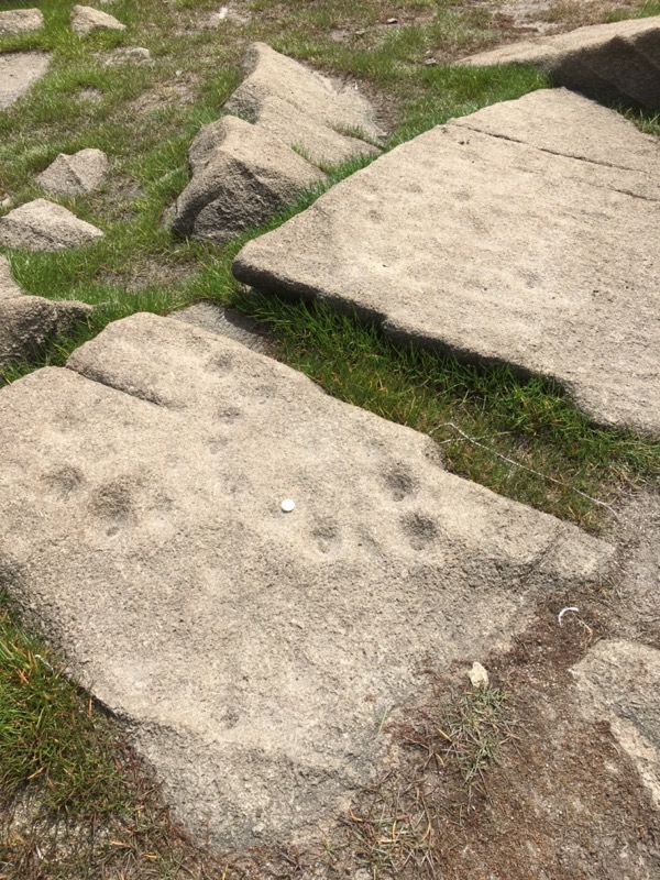
The extremely low water levels occurring during 2022 at Stithians Reservoir, situated around a mile west of the village of Stithians in Cornwall, served to reveal once again, an enduring archaeological puzzle as well as highlighting a crisis in Cornwall’s public water supply and crumbling public infrastructure.
Not seen since the very dry Summer of 1984, the 12 cup-marked granite slabs were once again revealed, normally being concealed beneath the waters of the reservoir.
Construction on Stithians Reservoir as it is called, and now representing the largest inland lake in West Cornwall, began in 1962 and the inundation commenced in 1967 ultimately flooding some 274 acres of farmland, three farming settlements and countless ancient sites.
This man-made lake is now surrounded by the remaining settlements bearing very Cornish names, amongst them Polmarth, Menherion, Nanpean, Penhalveor, Tresevern, Carnmeor, Lansenmeth, Trewarth and Menerdue amongst many others, a toponymic feast.
Within the surrounds of the reservoir, these cup stones lay, normally covered with water.

They are close to Menerdue and so perhaps should be more correctly referred to as the ‘Menerdue Stones’.
Stithians itself was recorded in 1268 as ‘Saint Stethyane’ named after the female Saint Stethyan.
Menerdue, where the stones lay, was recorded as ‘Menethdu’ in 1356 translating from the Cornish ‘menedh du’ as ‘dark’ or ‘black hillside’ and not ‘black stones’ as some have suggested. It would appear that even the Cornwall and Isles of Scilly’s Historic Environment records are incorrect in this respect recording the place as ‘Menerlue’ in a number of instances.
The dozen cup marked stones have been dated to the Bronze Age, the period 2500 BCE to 801 BCE although there is plenty of evidence that they predate even that.
Similar such man-made artifacts as these exist elsewhere and the Cornwall Archaeology Unit has recorded a total of 34 currently known sites ranging from hedge stones to the one found at Tregiffian barrow – Cruk Tregyffian – the chambered tomb found near Saint Buryan, this latter now under the careful management of the Cornwall Heritage Trust.
Similar cup-marked stones have been identified at a number of locations across the globe, in Ireland, Wales, the north of England, Scotland, Brittany, Portugal, Galicia, in the Italian Alpine valleys and Sardinia, Azerbaijan, Greece, Denmark, Sweden, Norway, Finland and in Switzerland as well as even further afield in Australia, Gabon, Mozambique, Israel, India, Mexico and the Americas
Writing in 1926, the very respected Dorothy Davison (1890 to 1984) said of the rock shelter of La Ferrassie in the Dordogne when describing the discovery of four skeletons there in the period 1909 to 1912 together with subsequent finding of two further skeletal remains, all dating from prehistoric and indeed probably Neanderthal times, that academic examinations recorded that: “the three-cornered grave was partially covered by a slab of stone of a similar shape. The lower side of this stone was pitted with several small cup holes, apparently arranged in pairs.”
Writing a little further of the same site and when describing the discovery that the head of a child’s skeleton had been removed from its body, she wrote, “Why the head was separated from the body and covered with a slab of stone pitted with cup holes is not known.”
She continued, “At a much later time cup holes such as these were used to hold blood or other liquid offerings, but in this case it is difficult to understand why the hollows were upside-down.”
The cup-marked stones at Menerdue were ‘rediscovered’ in the 1980s and local people were well aware of their existence and even collected flint tools from the area. Later, during the drought year of 1984, a member of the Cornwall Archaeological Unit, Don Cave, again ‘rediscovered’ them together with flint tool scatters nearby and made the effort to properly record and report them.

The Heritage Environment Record informs that: “the southern-most site, identified as Group A in the published report, consists of five stone slabs numbered 1 to 5, though stones 1, 2 and 3 appear to be the broken fragments of a single large stone. This large slab was decorated with at least 48 cup-marks; some were shallow with indistinct edges and originally there may have been 50 or more on this one slab. Stone 4 was an irregular slab with at least three (possibly five – some were shallow and indistinct) randomly spaced cup-marks; stone 5 was notable in that although it presented a reasonably flat surface, the cup-marks were arranged in two lines along one edge.”
Archaeoastronomer Carolyn Kennett visited the site during July, 2022 and commented:
“What’s interesting about the pre-history at Stithians is the amount of cup-marked stones. There are batches of them but they are really condensed together in a small area.”
“It is probably the most amount of cup-marked stones in one area in Cornwall, so it is the biggest amount of pre-historic rock art that we have.”
“It is not known why the markings were made but it is likely to have been done ‘artistically’”, she continued, adding, “Cup-marking is definitely late or mid-Neolithic and into the Bronze Age they would still be doing it, but it is incredibly difficult to date these type of things.”

“This year in particular they (referring to the water levels) are incredibly low. It’s exposing some of the medieval farmsteads that were covered over by the reservoir when it was flooded. It is really interesting to see how much has been exposed.”
“Cup-marked stones, and other remains of buildings and roads are also known to be beneath Drift Reservoir near Penzance.”
With the Bronze Age being around 4,000 years ago and with the Neolithic period predating that, we shall probably never know of the purpose for these cup-mark cuts in stones.
Many have speculated that they were made for decorative reasons. Others have suggested they were cut as sockets for other connecting stones. Some believe they were the work of idle hands and yet more believe they were of a ritual nature. There has even been a suggestion that they were a natural phenomenon. Certainly, in other instances they are connected with ancient funeral sites.
As is the case with the fogous, these ancient mysteries will surely remain just that.
References:
- Placenames in Cornwall and Scilly – Craig Weatherhill, Wessex Books in association with Westcountry Books, Launceston, Cornwall 2005
- Our Prehistoric Ancestors – Dorothy Davison, Methuen and Co. Ltd. London 1926
- Cornwall Event Report: The cup-marked stones of Stithians reservoir – S. Hartgroves, Cornish Archaeology No 26, 1987
- Archeoastronomy Cornwall website: https://archaeoastronomycornwall.com
All images provided by the author.
Stop Press: A further site with a cup-marked stone has recently been discovered by friend of the Journal, Tom Goskar, in the far west of Cornwall. Details can be found on his website.
Brown Willy is Cornwall’s highest hill, with a summit reaching 1,378 feet above sea level. Located among the rocky outcrops and desolate reaches of Bodmin Moor, with cairns that date back to the early Bronze Age, Brown Willy has been considered a sacred place for thousands of years.
But the true name for Brown Willy was recorded in 1280 as ‘Bronwenely’ derived from the Cornish language ‘bron wennyly’ meaning ‘swallows hill’, a much better name and far different from the Anglicised name we see now.

The summit cairn, which has never been excavated, is thought by some to be the resting-place of an ancient Cornish king.
Brown Willy’s cairn aligns with the neighbouring Rough Tor and the nearby Stannon stone circle, suggesting that their construction had some kind of astrological purpose.
The Aetherius Society even believe that Brown Willy is a holy mountain and make an annual pilgrimage here on the 23rd November.
Heavy rainfall occasionally gathers over Bodmin Moor after travelling downwind for a long distance, resulting in flash floods such as the one which occurred in Boscastle in 2004. The phenomenon is known in meteorological circles as the ‘Brown Willy Effect’.
With thanks to Myghal Map Serpren
Carn Galva (817ft), sometimes Galver, is the site of a Neolithic tor enclosure between Zennor and Morvah in West Penwith, Cornwall and is some 5,000 – 6,000 years old. Carn Galva sits in Zennor parish, within 1km of the coast, and provides a tremendous view of the sea to the north.
In 1861 John Thomas Blight, the Cornish author, illustrator and antiquarian, described Carn Galva in his A Week at the Land’s End as:
“a bold and curious pile of granite rock, about 623 feet above the level of the sea, is a conspicuous object from the locality. With the golden furze, purple heath, whortleberry, and the bright mosses and lichens on the rocks, this cairn has in colour a gorgeous appearance.”

It was called Castle Anowthan from the Cornish ‘castel an oghen’ translating as ‘castle of the oxen’. Castle Anowthan was mentioned twice in the 1580s, and then lost until 1984. John Norden in 1584 described it as:
“A craggy rock on the top of a hill near Zennor, upon the north sea, sometime trenched about and built with stone, as appeareth by the ruins of the walls.”
But no-one knew exactly where it was. Then a huge gorse fire on Carn Galva, exactly 400 years after Norden had last described it, exposed the remains of its walls, linking outcrop to outcrop, and its internal terraces.
Investigations at Carn Galva were undertaken by Cornwall Archaeological Society over a two-week period in 2009. Field survey after the 1984 fire had revealed walling around the southern tor on Carn Galva and it was believed that the site would prove to be an Early Neolithic tor enclosure. Two trenches were opened within the enclosure. The trenching at Carn Galva confirmed the presence of a substantial enclosure wall. Although the enclosure could not be dated, it seems probable that it is of prehistoric origin and comparison with excavated tor enclosures suggests a Neolithic date.
It’s certainly a “craggy rock” so, after 400 years in the wilderness – literally – welcome back, Castle Anowthan!

If Carn Galva means ‘lookout tor’, then that would logically belong to the hill’s northern peak, overlooking the sea, and it was raids from there that were potentially the greater threat, from prehistory right up until Napoleonic times.
So, maybe the big southern peak should be ‘Castle Anowthan’.
Toponomy
The difficulty is that the meaning of the name is not so clear. ‘Galva’ historic forms suggest ‘golva’, Cornish meaning ‘lookout’, but two ‘gallowa’ forms suggest ‘golowva’, Cornish meaning ‘beacon’.
Hunt and Bottrell both refer to Carn Galva as a former alarm beacon site.
‘Golow’ Cornish meaning ‘light’ and ‘va’ again Cornish meaning ‘place’ would be stressed on the first syllable, and that would tend to suppress the middle syllable, hence ‘gol’va’.
Short ‘A’ and ‘O’ tend to be interchangeable in Cornish speech, for example, Falmouth people call their town ‘Folmuth’, so that would explain the ‘A’ in the historic and current spellings.
In Cornish, ‘carn’ means a crag or tor, but it can also mean an artificial cairn. Everyone pronounces it wrongly though. It’s not like ‘barn’ or as they say that in English, ‘bahn’. The ‘A’ is like ‘cat’ but very slightly drawn-out, and the ‘R’ is pronounced.
Considering the views north and south from the top of Carn Galva/Castle Anowthan, the Iron Age cliff castle of Bosigran Castle can be seen off to the northwest, up on its 333ft cliff – the tallest vertical cliff there is in West Penwith.
In the event of a seaborne raid approach, an alarm beacon from there would be easily seen on Carn Galva, where another could be lit.
That, in turn, would warn most of Penwith, as several hill forts are visible from Carn Galva – Chun (which could signal to Caer Bran), Faugan Round, Lesingey and Castle-an-Dinas – which then signal to Trencrom and Carnsew Fort, even as far away as Tregonning Hill – Castle Pencaire.
The whole peninsula would be on alert within minutes!
The late Craig Weatherhill, whose research notes these are remarked,
“If you place your hand on the ground on top of Carn Galva, you can feel the beating heart of West Penwith!”
Toponymy by the late Craig Weatherhill.
Folklore:
William Bottrell relates the tale of a friendly Giant of Carn Galva, who accidentally kills his human best friend, and subsequently dies of grief.
Links:
Davies, Simon R. (2010). The early Neolithic tor enclosures of Southwest Britain. University of Birmingham. Ph.D.
Jones, Andy M (2019) Excavations at Carn Galva and Bosporthennis Quoit, West Penwith in 2009, Cornish Archaeology 58, 2019, 27–49
William Bottrell (1870) Traditions and Hearthside Stories of West Cornwall, Vol. 1
Good news for all Time Team fans:
New Time Team Episodes Coming Soon!
The wait is nearly over… We’re delighted to reveal the release dates for Time Team’s first brand new episodes in a decade! Further details coming soon.
Each of the two digs will premiere on the Time Team Official YouTube channel in an extended three-part weekend extravaganza. Get ready and subscribe: https://www.youtube.com/c/TimeTeamOfficial
The two digs being shown were both carried out during the pandemic.
The first from Cornwall features the work of the Meneague Archaeology Group at Boden on the Lizard Peninsula, overseen by James Gossip of the Cornwall Archaeology Unit, where the site includes an Iron Age settlement and associated fogou.
The second dig investigates the site of what could be a huge, high-status Roman villa at Broughton in Oxfordshire.
Further details of both these digs can be found on the Time Team Digital website.
Welcome back!!
Today is Plough Monday, traditionally the start of the agricultural year and the day when ploughs are taken back to the fields after the winter break.
In many parishes in the Midlands and East of England, a plough blessed in the church on the preceding Sunday would be paraded through the streets, collecting donations from householders. Those who refused would find their gardens ploughed over!

Sadly these days, the occasion is probably more celebrated by metal detectorists, keen to hoover up the shinies from the freshly ploughed fields.
The first example of Roman crucifixion in Great Britain has been unearthed in Fenstanton, Cambridgeshire.
Working ahead of a housing development near the small village of Fenstanton a team from Bedford based ‘Albion Archaeology’, members of which have been on site since 2017, have uncovered a previously unknown Roman settlement.
Five small cemeteries have been identified and the skeletal remains of 40 adults and five children buried identified with evidence that some were from the same families. The cemeteries have been dated to the third to fourth centuries CE.
In one of the graves, the skeleton of a man with a nail through his right heel bone was discovered. Further examination suggested that the man had suffered before he died with his legs bearing signs of infection or inflammation caused by either a systemic disorder or by being bound or shackled.

Archaeologist Kasia Gdaniec, speaking on behalf of Cambridgeshire County Council’s Historic Environment Team, said: “These cemeteries and the settlement that developed along the Roman road at Fenstanton are breaking ground in archaeological research.
“Burial practices are many and varied in the Roman period and evidence of ante- or post-mortem mutilation is occasionally seen, but never crucifixion.”
Cambridge University osteologist (bone specialist) of the university’s Wolfson College, Corinne Duhig said it was an “almost unique” find at what was a previously unknown Roman settlement.
She continued, “The lucky combination of good preservation and the nail being left in the bone has allowed me to examine this unique example when so many thousands have been lost. This shows that the inhabitants of even this small settlement at the edge of empire could not avoid Rome’s most barbaric punishment.”
Cambridgeshire Council said Corinne Duhig’s research into evidence of crucifixion from this period around the world revealed only three other possible examples, one from La Larda in Gavello, Italy, one from Mendes in Egypt and one from a burial found at Giv’at ha-Mivtar in north Jerusalem found during building work in 1968.
She found only the Jerusalem example to be a likely crucifixion because the right heel bone retained a nail which was in exactly the same position as the Fenstanton burial.
The county council said it was usual to remove any nails after crucifixion for re-use or disposal but in the Fenstanton case the nail had bent and become fixed in the bone.
During the excavation, a number of other items were unearthed including enamelled brooches, coins, decorated pottery and animal bones. Amongst the finds was an enamelled copper-alloy horse and rider brooch.
A large building and a formal yard or road surfaces indicated the presence of an organised Roman settlement with signs of trade and wealth, the council said. It said it hoped to be able to display the finds eventually.
Fenstanton’s High Street follows the route of the Via Devana, a road that linked the Roman towns of Cambridge and Godmanchester.
Links:
Cambridge University article dated 8th December 2021: https://www.cam.ac.uk/stories/romancrucifixion
Cambridgeshire County Council article dated 8th December 2021: https://www.cambridgeshire.gov.uk/news/the-first-example-of-a-roman-crucifixion-in-the-uk-has-been-found-in-a-cambridgeshire-village
Albion Archaeology: https://www.albionarchaeology.co.uk
Prior to Queen Elizabeth II ascending the throne in 1953, commemorative issue stamps were few and far between. Until then, such issues were limited to major events such as royal or postal anniversaries. This was to remain the case until the early 1960s, when the scope for commemoratives was widened somewhat to include other anniversaries, art festivals and major international business conferences or trade treaties. The first ‘non-event’ commemorative stamps were issued in 1966, with artistic views of British Landscapes, including views of Hassocks in Sussex, Antrim NI, Harlech Castle in Wales and the Caingorm mountains in Scotland.
On the 29th April 1968, a set of four stamps was released, depicting British Bridges, including the first ancient site to appear on a British stamp, Tarr Steps in Exmoor.

Although the frequency of commemorative sets increased, it was to be 22 years before another ancient site appeared. Strangely placed in a set released on 16th October 1990 celebrating Astronomy, Stonehenge made its first appearance.

The following year sets of definitive stamps were issued in a set of four archaeology-themed booklets, depicting Sir Arthur Evans at Knossos, Howard Carter at Tutankhamen’s Tomb, Sir Austen Layard in Assyria and Flinders Petrie at Giza.
June 1993 saw the first Roman-themed stamps issued, with portraits depicting Claudius, Hadrian, the Goddess Roma and a mosaic of Christ.
Ten years later, for the 250th anniversary of the British Museum in 2003, another set of portraits were issued which included the Sutton Hoo helmet.

April 2005 saw the release of the World Heritage set of stamps, which included three ancient British sites; Hadrian’s Wall, Stonehenge and neolithic Orkney.


In 2011 and 2012, two sets were issued featuring a UK A-Z which included Glastonbury Tor and Roman Bath.


Tarr Steps made a re-appearance in the March 2015 Bridges set.

The Ancient Britain set released in January 2017 included not only objects such as the Starr Carr antlers and the Battersea Shield, but also sites including Skara Brae, Maiden Castle and Avebury.


In June of last year, another set depicting Roman Britain was issued, the most recent release within our sphere of interest. This time the sites of Dover Lighthouse, Caerleon amphitheatre and Hadrian’s Wall (again) were included.


So over the years, it can be seen that Ancient Britain has been well represented on the stamps of Great Britain, with Tarr Steps, Hadrian’s Wall and Stonehenge all appearing more than once. Sadly, there are no stamps within our interest scheduled for this year, although folklorists have an Arthurian-themed set to look forward to.
Who, or what would you like to see on a British Archaeology set of stamps, if one were to be produced in future? Have you seen any examples of British sites on stamps from elsewhere in the world? Please leave a comment and let us know!
By Alan S.
The final video for now from our tour of Cornish antiquities visits the Carn Euny courtyard house settlement.
Continually occupied for over 800 years, the final phase of the settlement consisted of three large courtyard houses, several smaller oval buildings and a fogou. The fogou was discovered in 1857, and excavated in the 1860s by William Copeland Borlase.
Further information:
Carn Euny – Cornwall Heritage Trust
Carn Euny – Historic Cornwall
Carn Euny – Wikipedia
We hope you’ve enjoyed these videos as much as we enjoyed making them. Previous articles in the series can be found here. If there are other Cornish ancient sites you’d like to see featured, please leave a comment.


You must be logged in to post a comment.