
You are currently browsing the category archive for the ‘Megaliths’ category.
By Myghal Map Serpren
This menhir of locally sourced granite standing to a height of just under eight feet has had something of a chequered and indeed controversial recent history. It can be found on farmland set on the South Eastern side of the B3291 road at Eathorne Farm in the Parish of Mabe in Cornwall.
The name ‘Eathorne’ merits toponymical consideration. Even the recognised expert in this field, the late Craig Weatherhill found the name baffling and his research established that it was recorded as ‘Eytron’ in 1392 and later ‘Ethron’ in 1417. He suggested that the second syllable notably ‘thorne’ may derive from the Cornish language ‘tron’ meaning a ‘nose’ or ‘hillspur’.
Described by many as “slim and regular in shape with a curiously bent top” – a comment originally made by the late Craig Weatherhill in his book ‘Cornovia – Ancient Sites of Cornwall and Scilly’, current thinking indicates that this menhir was first erected in the Bronze Age (2500BCE to 801BCE), possibly fell or was moved and later re-erected during the Roman or post Roman period (43CE to 409CE).

A very public outcry resulted following no less than three accounts of a recent occurrence regarding the menhir:
- One informs that in June 1991, the landowning farmer determined the stone to be ‘an obstruction to the plough’ and removed it to behind a barn in the farmyard.
- A second account records that the stone was removed by the farmer in 1992 as he felt it a pagan artefact and an offence to his Christian beliefs.
- A third report has it that the same farmer removed the stone because ‘he felt uneasy about it’.
Whatever the actual facts are, doubtless somewhere between all three accounts, as a result of protest, the Eathorne Menhir was re-erected on 3rd October 1992, during ‘Archaeology Alive Week’ by members of the Cornwall Archaeological Unit, the Cornwall Archaeological Society and staff of Tehidy Country Park.
The Cornwall Archaeological Review of 1992 to 1993 recorded “the stone, which had been taken down by the farmer, is now near but not in, its original position”.
It appears that it had been placed close to a hedge so allowing it to become lost in vegetation and covered in fencing wire and that it had incurred damage as a result of the various moves.
By 2005, Eathorne Farm had undergone a change of ownership and the incoming farmer indicated support for the menhir being restored to its rightful spot.
Aerial photographs obtained in 1946 by the Royal Air Force and later in 1989 by Cornwall Council firmly identified its original position, so on 14th August, 2005, an eclectic team from the Historic Environment Service of Cornwall Council, the Cornwall Archaeological Society and the Cornwall Earth Mysteries Group undertook the work.
A mechanical digger was employed to remove the topsoil which revealed the original site, and during this operation, six flints, a number of pebbles and also notably charcoal was uncovered the latter of which was carefully retained to allow for radiocarbon dating.
The menhir was then re-erected in the correct position.
The subsequent radiocarbon procedure revealed the charcoal to have been oak and in the date range 120CE to 220CE with a 56% probability or 70CE to 240CE with a 95% probability. The results of this process has been used to date the menhir as previously discussed.
Said by some to be standing at a ‘sacred energy point’, the Eathorne Menhir does not appear to enjoy any form of scheduling or legal protection and whether there is some esoteric significance or not, it is of great historic and archaeological interest and one can but hope that the monument remains secure having finally returned to its original site.
References
- Placenames in Cornwall and Scilly – Craig Weatherhill, Wessex Books in association with Westcountry Books, Launceston, Cornwall 2005
- The Eathorne Menhir – paper by Andy M. Jones, Principal Archaeologist, Cornwall Archaeological Unit, Cornwall Council, 2006 in collaboration with Steve Hartgroves, Graeme Kirkham and Rowena Gale and Anna Lawson-Jones to which a link here: https://www.academia.edu/6605488/The_Eathorne_Menhir
- Cornovia, Ancient Sites of Cornwall & Scilly 4000 BC – 1000 AD – Craig Weatherhill, Halsgrove, 2011
All images author’s own, except where stated.
See similar articles by Myghal Map Serpren
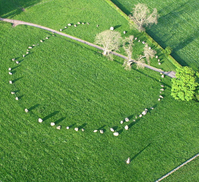
A regular contributor to the Heritage Journal, Myghal Map Serpren, has recently been spending some time in the Lake District. During his perambulations in the area, he stopped off at the well-known monument of Long Meg and her Daughters.
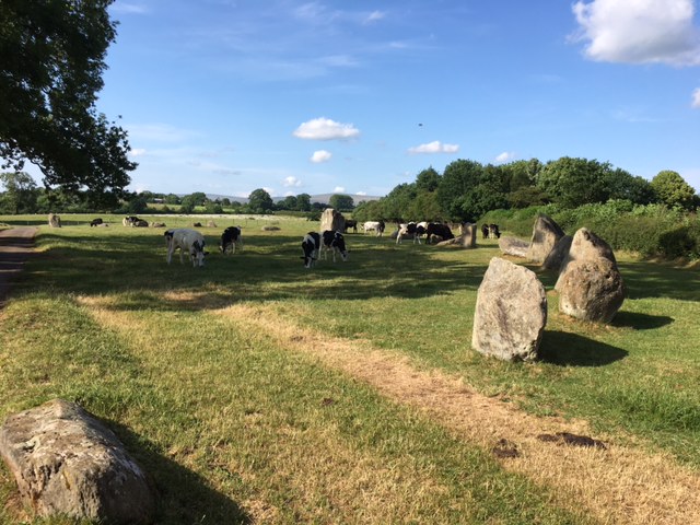
The monument consists of a circle of some 59 stones (the Daughters). This stone circle is the third widest in England, after Avebury and Stanton Drew. The circle is accompanied by an outlier stone (Long Meg) which is marked with examples of megalithic art including a cup and ring mark, a spiral, and rings of concentric circles.
By Simon Ledingham, CC BY-SA 2.0, https://commons.wikimedia.org/w/index.php?curid=1310796
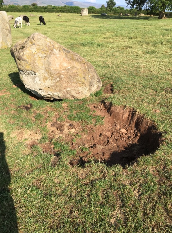
Whilst there, evidence of digging or excavation was seen next to one of the stones, and advice was sought from us here at the Heritage Journal as to what the best course of action would be with regard to reporting the quite obvious, visible damage:
In such cases, there are three initial choices that we recommend:
- If damage or desecration is currently being carried out, and the perpetrators are present or nearby, if it is safe to do so – call the police.
- If damage or desecration has been carried out, and no obvious perpetrators are nearby, contact the Heritage Environment Records Officer – HERO – for the relevant area (usually at County level)
- If damage is minor, or the above cannot be contacted, then try to identify a contact for a local Archaeology Society in the area, who will know who best to contact for further action.
In this situation, we suggested the HER officer as the best person to contact. We checked the Heritage Gateway website to find contact details for the appropriate officer – in this case, the one for Cumbria.
An email enquiry with photos of the suspected damage was despatched, and within 24 hours a reply was received:
Thank you for your email and alerting us to potential damage at Long Meg. Long Meg is a scheduled monument and thus the due restriction of Historic England. I have therefore taken the liberty of forwarding your concerns to the regional inspectors of monuments. I am not sure what has caused this disturbance, but there are management agreements in place with the farmer, and over the last few years we have worked hard to improve the overall condition of the site. You may have noticed that a new car park has been constructed, with the hope of keeping vehicles off the monument. We were aware that there were significant issues with rabbits on site last year, burrowing under the stones. Officers from Historic England were aiming to address this with the farmer. The latest damage may be due to the cattle in the field, but I hope that someone will be able to look into it quickly and prevent it from worsening.
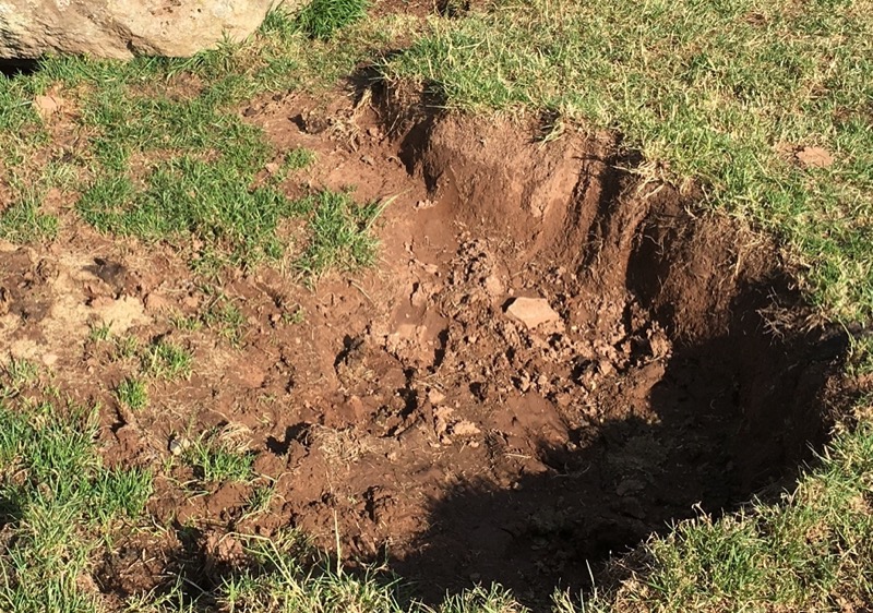
An interesting response, particularly with the reference to rabbit or cattle damage. Looking closer at the picture of the damage, it looks very much (to the untrained eye!) as if a shovel or spade has been used to dig the sides of the hole. Of course, there may be a logical or innocent explanation for the hole, but here at the Heritage Journal, given our concern regarding metal detecting we can’t help but wonder if someone received a strong signal and couldn’t help but help themselves to whatever was buried there?
What do HERO’s do?
Historic Environment Records (sometimes referred to as Sites and Monuments Records or HER) may be held by County Councils, District Councils or Unitary Authorities. In each case, the record will cover the whole of the local authority area. Selected major historic towns and cities are covered by Urban Archaeological Databases (UADs). In many cases, UADs are held as part of, and are accessible via, the local Historic Environment Record.
Each local Historic Environment Record is maintained by a local HERO, who will usually have a Planning or Archaeological background. The HERO is responsible for maintaining the Heritage Environment Record for their area, and for providing advice on planning issues, and safeguarding of heritage assets in their area.
In many cases, they will maintain good relationships with landowners, archaeologists and local and national societies, and are often a mine of useful information. They will pass on any information regarding damage or desecration to the appropriate authority for further action.
Although often stretched with regard to resources needed to do their jobs, a good HERO will respond in a timely manner to all enquiries – as did the one above! Be aware though, that many HERs may charge for responding to queries, particularly with regard to planning and development issues which require extensive research.
So, if you have a query about damage or desecration of a monument, don’t forget to embrace your local HERO!
STOP PRESS
Following publication of the story above, we received correspondence which confirms the HER Officer comments above, attributing the damage to cattle:
As soon as I saw the photo, I immediately ‘knew’ the source.
It is absolutely consistent with cattle ‘dust bathing’. I’m very familiar with the feature from many other places in Cumbria (usually on the west coast) where the loam soils are sandy, usually coastal grassland, areas where the parent material is fluvio-glacial outwash or recent blown sand.
Whilst it’s good to have it confirmed that the damage is ‘natural’ in origin, we can only hope that the site custodian will be advised that such damage detracts from the ambience of the site, and that remedial action will be taken in due course.
By Myghal Map Serpren
Seaureaugh Farm, near Stithians in Cornwall, stands on a settlement which has seen human occupation for over a thousand years and in the centre of an adjacent field named ‘Well Crow’ is found a possible Prehistoric granite megalith.
This field name contains the Cornish element ‘crous’ now recorded as ‘crow’ and translates into English as ‘cross’ and it is suspected that this was the site of the Celtic Cross relocated to the churchyard of Stithians Parish Church in 1910.
The interestingly named Seaureaugh, now often spelt ‘Sewrah’, is another wonderful example of Cornish toponymy dating from 1356 when it was recorded as ‘Syuwragh’. This is derived from the Cornish ‘gwragh’ mutated to ‘wragh’ meaning ‘hag’ or ‘crone’ in English preceded in all likelihood by ‘resyow’ translating in to English as ‘fords’.
Of the suspected megalith’s past, little is known.

It does closely resemble a Bronze Age menhir and is in an area where other Prehistoric remains and traces have been found and recorded. It is certainly far larger than almost all cattle rubbing stones and local farmers recount of its existence since time immemorial.
It has been recorded officially now following a 2007 report submitted by the Cornwall Farming and Wildlife Advisory Group although the mystery surrounding it may forever remain.
References:
- Placenames in Cornwall and Scilly – Craig Weatherhill, Wessex Books in association with Westcountry Books, Launceston, Cornwall 2005
- A Guide to Cornish Place-Names – R. Morton Nance, The Federation of Old Cornwall Societies 1956
Image obtained by author.
A guest article by Myghal Map Serpren
“Long, long ago, stones were alive. They spoke and delivered judgments, distinguishing the rightful king from the usurper, the honest man from the thief. They made men, strong and true; women, loving and fruitful. Once upon a time stones behaved just like mortals; they ate; walked down to the nearest river to drink; grew tall and strong; they even reproduced their kind! Now they do none of these things; they are inert, lifeless, dead; indeed “stone dead” has passed into a proverb.”
T.G.F. Dexter Ph.D., B.A., B.Sc. ‘The Sacred Stone – Origins of Stone Worship in Cornwall’ 1932
One of these mysterious standing stones, Boswens Menhir, in West Penwith is the mute ‘star’ of Cornish filmmaker Mark Jenkin’s movie ‘Enys Men’, the experimental Cornish folk production which premiered at the 2022 Cannes Film Festival to critical acclaim and which has subsequently been seen in packed cinemas elsewhere.
Mark knows a thing or two about Cornwall. He was born there and understands the significance of the ancient sites.
‘Enys Men’ which translates into English as ‘Stone Island’ from Kernewek, the autochthonous Brythonic Celtic tongue of Cornwall, has most certainly highlighted many things, amongst them the fact that these ancient sites remain an important part of indigenous Cornish life and that the Cornish language is far more common than many wish to believe.

In Cornwall is to be found one of the most intensive prehistoric landscapes on the island of Britain. There are probably more ancient sites here than almost anywhere else in Europe and a vast number of them are so aged that they predate the Egyptian pyramids.
Furthermore, such ancient sites including the many menhirs, are very much cared for, respected and even worshipped, particularly by Cornwall’s growing numbers of Pagans, with those who follow this path forming the Duchy’s third largest faith community.
Penwith, the district of Cornwall which has so many archaeological riches, is fortunate enough to have the services of the Cornwall Ancient Sites Protection Network (CASPN / RGHL) whose members keep a caring watch over the various monuments and structures, reporting on them and occasionally carrying out valuable clearances.
Together with many other such relics, the Boswens Menhir has a character of its own. Situated on the northern hillside of Dry Carn, this long stone was probably erected in the Bronze Age.
The name ‘menhir’ is again a Cornish language word, a word common in the other Brythonic Celtic tongues translating to English as ‘Long Stone’ (‘men’ being ‘stone’, ‘hir’ being ‘long’).
The place name ‘Boswens’ was first recorded as ‘Boswyns’ in 1329, Cornish meaning ‘windy dwelling’. ‘Dry Carn’ was recorded as ‘Tricarn’ in around 1300, literally ‘three cairns’ from the Cornish ‘try carn’.
The moor at Boswens Croft also contains a barrow and remains of medieval field strips.
The menhir in question stands some 2.7 metres (nine feet) high above ground and extends to an unknown depth below ground, and until more recent times, it protruded from a small cairn of stones of which vague hints remain. The cairn was certainly visible when Dr William Borlase, that great antiquary, geologist and naturalist visited the site 250 years ago and wrote about it.
It has been said that Boswens Menhir strongly resembles the shape of a woman dressed in a long robe and hood, but what really adds to the air of mystery is that the stone’s shape alters quite dramatically when seen from differing viewpoints. It is almost as though the hard rock is malleable and changes its form.

Myth has it that animals fear approaching the stone and this is hardly surprising in that this rather eerie monolith has stared across the landscape for 4,000 years, perhaps staring at other ancient sites at Tregeseal Stone Circle and Chun Quoit which are visible from the site.
A further strange and currently unexplained property of this stone can be seen on the rare occasion when snow settles leaving clear a circle of ground around the menhir roughly the extent of the former cairn.
Clooties are a common sight at Cornwall’s many sacred wells and springs although perhaps rather sadly, many of these are not biodegradable. It is also common to see votive offerings at menhirs and cromlechs and they are often found at Boswens comprising heather placed into a fissure in the monolith.

Pagan and Druidic ceremonies are very common at these ancient sites together with seekers of earth energies and dowsers, as well as those who merely visit to view them and absorb the atmosphere and perhaps pay homage.
In 2014, when the cromlech at Carwynnen Quoit on the Pendarves Estate near Camborne in west Cornwall was skilfully restored by The Sustainable Trust to its 5,000-year-old glorious completeness, literally hundreds of volunteering people were involved with both the restoration of this portal dolmen and celebrating its ‘reopening’ day and the return of its capstone to its home, as queues of cars and crowds blocked the roads and loud cheering and clapping was heard at the return to life of ‘The Giant’s Quoit’.
Perhaps life is returning to these granite monoliths erected millennia ago and that they are not ‘stone dead’ as asserted by Dr. Dexter?
References
- The Sacred Stone – The Origins Of Stone Worship In Cornwall – T.F.G. Dexter Ph.D., B.A., B.Sc., Ne Knowledge Press, Perranporth, Cornwall 1932; reprinted Oakmagic Publications, Penzance 1998
- The Principal Antiquities Of The Land’s End – Professor Charles Thomas M.A., F.S.A., P.A.S. Pool M.A., F.S.A., Craig Weatherhill, Cornwall Archaeological Society 1954; 16th Edition reprinted 1980
- Placenames in Cornwall and Scilly – Craig Weatherhill, Wessex Books in association with Westcountry Books, Launceston, Cornwall 2005
- Cornovia – Ancient Sites of Cornwall & Scilly 4000 BC – 1000 AD – Craig Weatherhill, Halsgrove, Wellington, Somerset 2009
- Cornwall Ancient Sites Protection Network (CASPN) Roesweyth Gwith Hen Leow Kernewek – Lelant Downs, Hayle, Cornwall
Website: https://cornishancientsites.com/contact/ - The Giant’s Quoit, Carwynnen, Camborne – The Sustainable Trust
Website: http://www.giantsquoit.org - Agan Tavas – The Society for the promotion of the use and study of the Cornish language – Portreath, Cornwall
Website: https://www.agantavas.com
Burras is a small hamlet situated between Redruth and Helston in Cornwall.
Recorded as ‘Berres’ in 1337, the name is derived from the Cornish language ‘ber-res’ translating as ‘short ford’. It is sometimes known as ‘Burhos’ and there is a ‘Burras Farm’ and a ‘Burhos Farm’.
A 19th-century milestone survives in the hamlet. It is a painted dressed granite monolith with a pyramidal head, triangular in plan shaft over a square in plan base and is inscribed on the left side: ‘REDRUTH 5 MILES’ and the right-hand side inscription: ‘HELSTON 5 MILES’
The road bridge over the River Cober which runs through the hamlet dates from the early 19th century and is a listed structure comprising granite rubble with roughly-hewn granite monoliths as lintels. It is a two-span bridge of primitive lintelled construction with iron railings. The railings are threaded through iron stanchions between terminal granite monoliths at either side of the bridge while the lintels are linked by iron cramps.
Burras Menhir can be found at Lezerea Farm a short distance south of the river. This impressive Bronze Age standing stone measures 12 feet 5 inches in height and is a listed monument.

It may not stand in its original site and local historian Michael Tangye in 1971 records the re-erection of the stone in a large pit during the early 1900s by the brothers Pearce with the use of a steam engine, in the presence of Sir George Smith, the owner of the land.
Traces of one of several Iron Age Rounds in the area has been identified by crop marks just a few fields to the south-east.
Toponymy by the late Craig Weatherhill.
With thanks to Myghal Map Serpren.
Some four years ago now, we asked “What next for London Stone?” It appears that at long last that question will been answered, as from this Friday 13th London Stone will be on display in its new temporary home at the Museum of London whilst redevelopment of the site at 111 Cannon Street goes ahead.

The stone will be displayed in the Museum of London’s War, Plague & Fire gallery, and will remain at the museum while work is carried out to rebuild its previous home on Cannon Street.
The stone’s origins are bathed in myth, and it is said to hold the fate of London in its hands should it ever be removed or destroyed. Let’s wait and see…
A couple of years ago, we took a Heritage Drive through Herts, Cambs and Essex, on the way passing the Leper Stone at Newport, a short distance south from Saffron Walden in Essex. We recently had an opportunity to revisit the area and take a closer look at the Newport Stone.
The stone, which is the largest standing sarsen in Essex, is situated on a grass verge on the east side of the B1383, just north of the village of Newport. The River Cam flows just a few metres further to the east. I’ll admit up front that the origin and age of the stone is in some doubt – was it raised in prehistoric times, or is it medieval? The St Mary and St Leonard’s Hospital was a lay establishment founded nearby by Richard de Newporte during the reign of King John (1199-1216) and was thought to have been a leper hospital, but no definite proof of this exists. Nevertheless, the stone is said to have been used as a ‘trading point’ for the hospital, where goods or alms would be left for the victims. There is a small depression on top of the stone where money may have been left washed in water or vinegar as payment, though it has to be said that many similar ‘plague’ stones with depressions in the top have identical stories behind them, many without any basis in fact. In this case, the hospital did exist, and stones from part of the old hospital can still be seen built in to the modern wall by the footpath.

Newport Stone from the south, showing the older blocks in the wall alongside.
There is of course no surefire way of dating the stone and its current setting, but the fact it is set upright (an unusual position for glacial erratics to come to rest) points to it’s having been purposefully placed. I can find no record of any excavation though it is likely that the stone has been disturbed, and possibly moved, not least when the modern road was laid. Perhaps it was originally placed as a marker stone for an easy crossing across the Cam? Unfortunately there is no mention of the stone on O.S. maps from the mid 1800’s up until at least 1923, though the site of the hospital is marked. So either it’s a comparatively recent placing, or the O.S. ignored/missed the stone and concentrated on the hospital site.
An interesting item in the Essex Field Club Journal from 1884 (v4 p95) suggests that the area exhibited signs of habitation, in the form of worked tools, from before the last Glacial period i.e. before the stone would have been deposited by the glaciers:
Mr. Greenhill thought, with those who had taken up the study, that there was no longer any question as to the comparative age of these implementiferous deposits compared with the Glacial period. During the winter he had travelled down by road to Saffron Walden, to examine all possible sections in the Lea and Stort Valleys with this object only in view, and at Newport, in Essex, he had found an implement which equalled in elegance of form anything that was upon the table that evening. It was now in the possession of the Head Master of Newport Grammar School. He (Mr. Greenhill) immediately went to the spot where this implement was obtained*, and satisfied himself that it had come from a position under what was there known as the Chalky Boulder Drift. There was plenty of proof that the men who used these implements were living, at least, in inter-glacial times, and, indeed, in pre-glacial times. The implements which he had brought to the meeting were entirely pre-glacial—that was to say, they dated before the last Glacial period.
I wonder whether the implement in question is still held at the school?

Newport Stone from the north.
Speaking of marker stones, the village has another stone of note slightly further south near to the train station. In this case the stone is puddingstone, a conglomerate stone which was often used to mark crossing points at rivers. indeed there is the theory of a prehistoric ‘Puddingstone Trail’, set forth by Dr Rudge and his wife based upon their research into puddingstones in the 1950’s. They suggested that a “Puddingstone Trail” predating the Romans may have been waymarked stretching from Grimes Graves in Norfolk to Stonehenge in Wiltshire. More information on the Puddingstone Trail may be found on the Megalithic Portal web site.


You must be logged in to post a comment.